01/18/26 - 01/24/26
Southern Climate Region Weekly Summary, 01/18/26-01/24/26
Climate in the News:
A historic winter storm is in the process of exiting the Southern Region on Sunday (01/25) after producing heavy snowfall from the Texas Panhandle to western Tennessee. This winter storm brought significant sleet and freezing rain accumulations from Central Texas to East Tennessee. Lingering impacts on Sunday include additional freezing rain and ice accumulations across northern Mississippi and much of Tennessee, where up to an additional half inch of ice is possible to begin the new week.
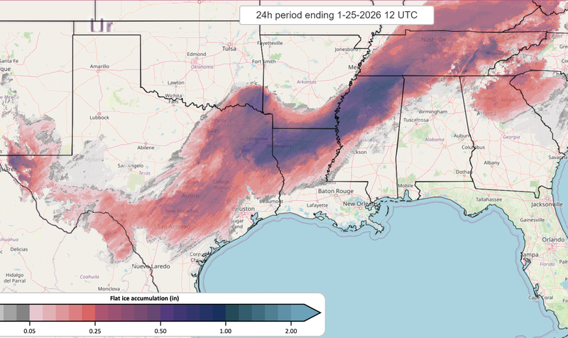
National Severe Storm Laboratory 24-hour Flat Ice Accumulation (inches) valid: 01/25/26 6am CST
A prolonged period of historic cold is expected across the Southern Region from Sunday (01/25) through Wednesday (01/28) as post-frontal conditions dominate much of the week. Record low temperatures are set to be broken in Central Arkansas, Mississippi, southern Oklahoma, Tennessee, and much of Texas on Sunday. A high-pressure system is expected to build over Texas Monday and Tuesday, helping trap cold air across the region; multiple cities across the Southern Region are forecast to break record low maximums and minimum temperatures throughout the week. Starting on Friday (01/23) large portions of the Southern Region are forecast to remain below freezing for more than 72 hours From Wednesday (01/28) through Friday (01/30) temperatures are expected to remain slightly below average as southerly winds gradually return and high pressure shifts eastward. On Friday (01/30) a surface low-pressure system is expected to develop off the Texas and Louisiana coast which will produce light coastal showers from Texas to Mississippi with most accumulations remaining under one inch.
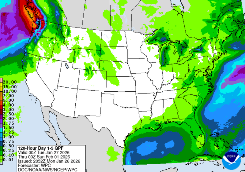
Weather Prediction Center Quantitative Precipitation Forecast Day 1-5 valid: 6pm CST 01/26/26 - 6pm CST 01/31/26
Another low-pressure system and its trailing cold front are expected to emerge from the Rockies and move east across the northern portions of the region; this system is expected to deliver a dry cold front late in the week. Temperatures are forecasted to be 10 to 15 degrees below normal from Friday (01/30) into Saturday (01/30).
Weather Synopsis:
The Southern Region experienced multiple frontal passages from Sunday (01/18) through Saturday (01/24). Sunday (01/18) was dry across the region, with temperatures well above seasonal norms as high-pressure off the Gulf Coast and a nearby warm front promoted above-average warmth and suppressed precipitation. A weakening low-pressure system moved eastward across the Great Lakes on Monday (01/19), pushing a cold front southward into the region; the front quickly weakened and stalled across Texas, Louisiana, and Mississippi. This stalled boundary allowed temperatures to remain above seasonal averages and produced scattered showers from Wednesday (01/21) through Thursday (01/22). By Friday (01/23) the setup for the historic winter storm was underway as an intense low-pressure system moved eastward through southern Canada, drawing Arctic air southward behind its cold front. Simultaneously, a surface low-pressure system formed over western Texas which transported Pacific and Gulf moisture into the region ahead of the advancing Arctic front.
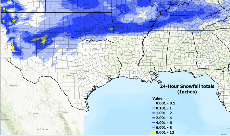
24-hour snowfall totals (inches) for the Southern Region valid: 01/24/26 6pm CST
Snow began falling across northwest Oklahoma during the early afternoon on Friday (01/23) and quickly expanded southward across the region. By Friday night into Saturday morning (01/24) a persistent wintry mix covered much of the Southern Region and continued through Saturday night.
Temperatures:
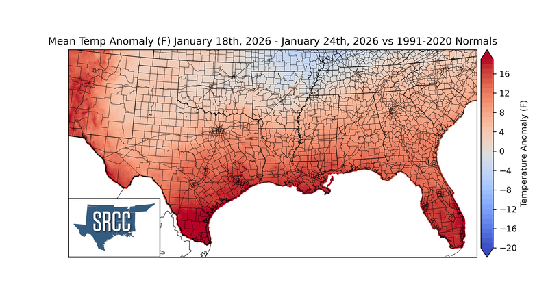
Despite multiple frontal passages and associated rainfall, temperatures across much of the Southern Region remained anomalously above normal. Across the northern portions of the region from the Panhandle of Texas to eastern Tennessee, temperature anomalies remained near normal with minor fluctuations above and below average. Farther south across Texas, Louisiana, and Mississippi temperature anomalies ranged from 4 to 12 degrees above normal, with peaks near 20 degrees above normal in southern Texas and Louisiana. Average temperatures for the week ranged from the upper 20s to upper 30s across Oklahoma, Arkansas, and Tennessee. Across the central portions of Texas, Louisiana, and Mississippi, average temperatures remained in the mid 40s. Farther south where temperature anomalies were greatest, temperatures were in the 50s and 60s.
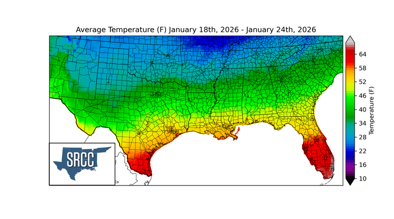
As the Arctic cold front passed through Friday evening into early Saturday morning, record low maximum temperatures were set across the Southern Region on Saturday (01/24). Widespread record low maximum temperatures were observed across Texas, Arkansas, Oklahoma, and northern Louisiana. Much of Texas failed to rise above freezing on Saturday, with temperatures remaining in the low 30s statewide; Amarillo and Lubbock set record low maximums in the single digits and teens. Across Oklahoma, colder air settled in, keeping highs limited to just 4 to 7 degrees in northwestern portions such as Gage and Clinton; Oklahoma City and Stillwater set record low maximums in the teens. Arkansas recorded low maximum temperatures from Fayetteville to Little Rock, with highs remaining in the low to mid 20s. Further south Shreveport, Louisiana recorded a record low maximum temperature of 32 degrees for Saturday (01/24).
Precipitation:
Widespread showers on Wednesday and the historic winter storm resulted in precipitation totals near to slightly above normal across much of the Southern Region. From western Texas to northern Mississippi, precipitation anomalies ranged from 200 to 300 percent above normal due to widespread totals of at least one inch. A broad swath of precipitation totals near three inches extended from central Texas into northern Mississippi. The historic winter storm produced ice accumulations ranging from 0.1 to 0.5 inches from West and Central Texas to Tennessee as the storm moved eastward through Friday and Saturday.
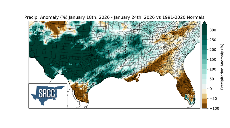
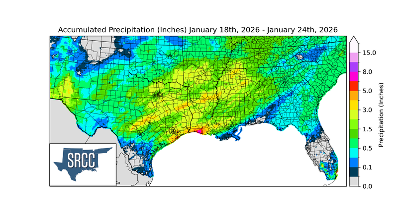
Peak snowfall totals of 8 to 12 inches were observed in Amarillo, TX and near the Oklahoma-Arkansas border. Southern Texas and coastal portions of Louisiana and Mississippi were the only areas that recorded below-normal precipitation with weekly totals remaining under 0.5 inches.
Drought:
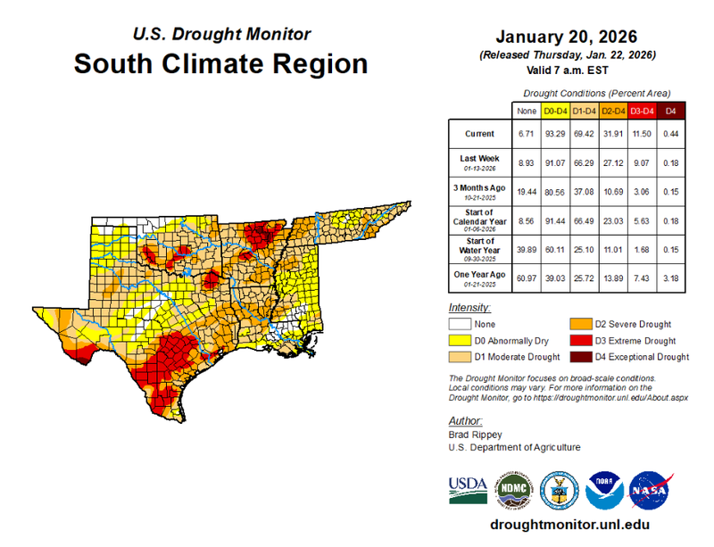
U.S. Drought Monitor Cumulative Statistics for the Southern Region valid: 01/20/26
Drought conditions worsened across the Southern Region, with Abnormally Dry (D0) to Exceptional Drought (D4) now covering 93% of the region, up from 91% the previous week. Severe Drought (D2) through Exceptional Drought (D4) showed the largest increases that expanded from 27% to 31% of the region, expansions were observed from south-central Texas into northern Mississippi. A new area of Exceptional Drought (D4) was introduced in northeast Arkansas after multiple weeks of limited rainfall; regional D4 coverage increased from 0.18% to 0.44%.