01/11/2026 - 01/17/26
Southern Climate Region Weekly Summary, 01/11/26 - 01/17/26
Climate in the News:
A dynamic weather pattern is expected across the Southern Region, with post-frontal conditions dominating from Sunday (01/18) through Tuesday (01/20) bringing northerly winds, below-average temperature, and dry conditions. On Tuesday a low-pressure system will move across the northern portion of the region, bringing minimal precipitation from Texas to Arkansas. Its trailing cold front will dive south on Wednesday (01/21), prompting a marginal excessive rainfall risk across southeast Texas and southern Louisiana. Rain chances are expected to shift eastward into Mississippi and Tennessee on Thursday (01/22) as the cold front stalls along the Gulf Coast and high-pressure builds across Oklahoma.
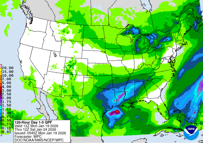
Weather Prediction Center Quantitative Precipitation Forecast Day 1-5 valid: 6am CST 01/19/26 - 6am CST 01/24/26
As this high-pressure system moves eastward into the Carolinas on Friday (01/23), another low-pressure system emerges from the Rockies and moves across the Southern Region, bringing Arctic air, snow, and mixed precipitation into the weekend. Sub-freezing temperatures are expected across much of the Southern Region, with precipitation totals exceeding one inch from east Texas to eastern Tennessee. Snowfall is expected across Oklahoma, Arkansas, and Tennessee, with the highest accumulations likely in Tennessee. Farther south a mix of winter precipitation is expected across Texas, Louisiana, and Mississippi where accumulations could become significant. Total precipitation amounts may reach up to three inches from eastern Texas to southern Tennessee.
Weather Synopsis:
The Southern Region began the week with above average temperatures, clear skies, and southerly winds Sunday (01/11) through Wednesday (01/14) as a high-pressure system remained over the Lower Mississippi River Valley. Early in the week, waves of Pacific moisture produced up to once inch of rainfall across western Texas. A low-pressure system moving through the Ohio River Valley pushed a trailing cold front southward into the Southern Region on Wednesday evening (01/14). The cold front had remained mostly dry but produced minor precipitation from central Texas to Tennessee with totals near 1.5 inch and light snow accumulations in eastern Tennessee. Temperatures remained near seasonal averages until another strong low-pressure system moved across the Great Lakes and pushed a cold front through the region on Friday afternoon and evening (01/16).
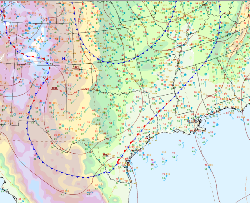
Weather Prediction Center Surface Analysis for the Southern Region valid: 6pm CST 01/16/26
The cold front remained dry across Oklahoma, Texas, Louisiana, and Arkansas where temperatures quickly dropped and strong winds across the region prompted fire weather warnings in Oklahoma and Texas. Mississippi and Tennessee received light rainfall, with additional minor winter precipitation reported in eastern Tennessee. Low temperatures on Saturday (01/17) were the coldest of the year so far, with readings falling into the teens across the northern portions of the region and below freezing across most areas.
Temperatures:
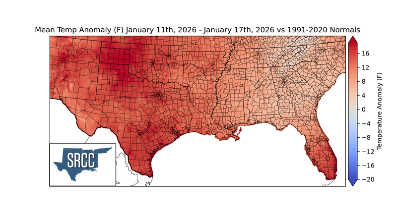
Despite multiple frontal passages, the Southern Region recorded above-normal temperatures for this time of year. Temperature anomalies peaked across the Oklahoma and Texas Panhandles, where values reached nearly 10 degrees above normal due to clear skies, southerly winds, and limited precipitation. Above average temperature anomalies decreased eastward with temperatures being 4 degrees above normal across Mississippi and Tennessee.
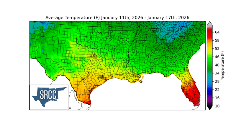
Average temperatures across the Southern Region were in the mid to low 40s for the week. The highest weekly average temperatures were observed along the Texas coast, where values reached the upper 50s. Eastern Tennessee recorded the lowest weekly average temperatures, with values in the low 30s following multiple rounds of winter precipitation.
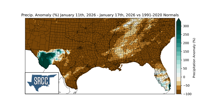
Precipitation:
Precipitation totals across the Southern Region remained limited, with no locations exceeding two inches for the week. The majority of the Southern Region remained drier than normal, except for portions of West Texas. Precipitation anomalies were near -100% across Oklahoma, Arkansas, Louisiana, and Texas with smaller deficits observed across Tennessee and Mississippi. Waves of Pacific moisture from Monday through Tuesday produced above-average precipitation in western Texas, where totals exceeded 1.5 inch which represented a 300% anomaly for this time of year.
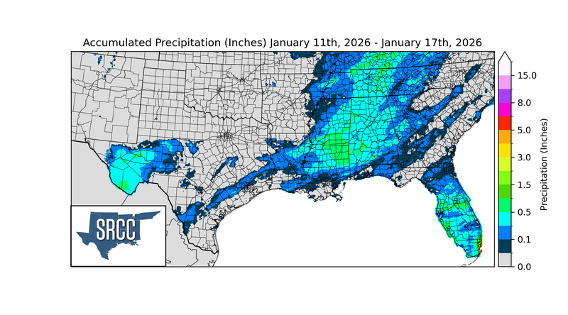
Two frontal passages during the week produced minor precipitation from central Texas to eastern Tennessee, with most areas receiving less than 0.5 inches of precipitation and localized totals nearing 1.5 inches in parts of central Mississippi and Tennessee. Oklahoma, central and northern Arkansas, and much of Texas recorded no measurable precipitation during the week.
Drought:
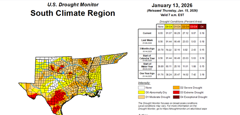
U.S. Drought Monitor Cumulative Statistics for the Southern Region valid: 01/13/26
With temperatures remaining slightly above average and limited precipitation, drought conditions largely persisted with 91% of the Southern Region experiencing drought conditions. Coastal showers along Mississippi and Louisiana led to localized improvements and eased drought conditions. Oklahoma, Arkansas, and much of Texas remained largely dry resulting in continued drought expansions. Extreme Drought (D3) to Exceptional Drought (D4) expanded from 5% to 9% of the region, with increases observed in southern and northeast Texas, southern Oklahoma, and northwest Arkansas.