6/02/2024 - 6/08/2024
Climate in the News:
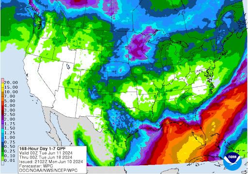
The first full week of Meteorological Summer has passed! While hot temperatures are a concern as the summer progresses, this week’s chances of being climatologically above-normal are slim because of rainfall. Severe thunderstorms and excessive precipitation are the primary hazards over the next week for the Southern Region. Parts of west-central Texas and coastal Louisiana are expected to receive rainfall from Monday, June 10th through Wednesday, June 12th totaling up to 2.5 inches over the week. The Mississippi coast is expected to receive the most precipitation this week totaling up to 4 to 5 inches on Monday, June 17th. Heavy rain and flooding concerns dominate the Southern Region over the next week especially along coastal areas.
Weather Synopsis:
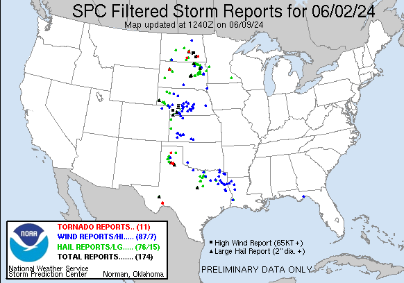
Sunday, June 2nd exploded with severe thunderstorm activity throughout the Great Plains. An upper-level trough moved eastward across the Southern Region. Aided by a dryline which extended southward from the Panhandle, storms formed and moved eastward in a strong bow-shaped line (indicating strong winds), across Oklahoma and North Texas. Meanwhile, thunderstorms formed in east Texas and southern Louisiana. Eventually, both lines joined together and moved slowly over Louisiana as the storm system weakened.
Notable Reports:
- Tornadoes were observed in three locations:
- Two tornadoes formed from the same supercell in Sanderson, TX.
- Briscoe County, TX
- Two tornadoes in Sanford, TX
- Estimated 7.25-inch hail was found in Swisher, TX
- Record breaking for the state of Texas!
- The Storm Prediction Center described it “as long as a 16 oz Monster Nitro energy drink can".
- 6-inch hail was found in Briscoe, TX.
- 67 mph wind gust was recorded in Jackson, OK.
Temperature:
Climatologically, June is the third-hottest month of the year for the Southern Region. High average temperatures become consistent at typically 70 to 80 degrees Fahrenheit. As the sun's heating increasingly concentrates northward, the temperature spread across the Southern Region, between the southernmost point of Texas and the northern portions of Tennessee and Arkansas, becomes generally even.
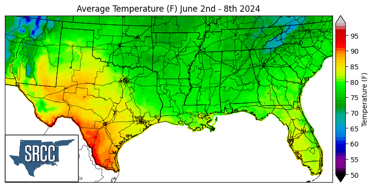
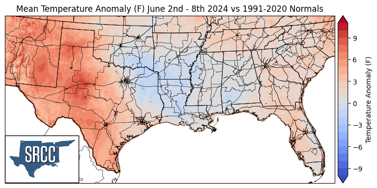
Last week, temperatures were warm to mild across the Southern Region thanks to cloud cover and multiple rain days. Temperatures were above-average or stayed near average. South of the Texas Panhandle exceeded 9 degrees Fahrenheit above normal, while much of the ArkLaTex region saw temperatures as cool as 3 degrees below normal. Average temperatures were consistently in the high 70s throughout the Southern Region, but Texas temperatures remained varied. Southern Texas temperatures exceeded 90 degrees Fahrenheit leading the rest of the Southern Region in the heat that is on its way up to northern portions by next week according to the Weather Prediction Center.
Precipitation:
Climatologically in June, precipitation begins to concentrate along the coastal regions of the Dixie Alley. For the Southern Region this tends to be along east Texas to southern Mississippi. Rainfall inland remains but becomes less frequent compared to the month of May.
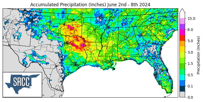
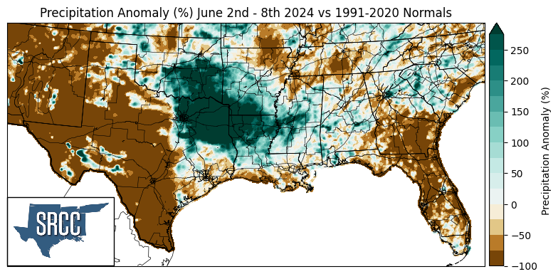
Last week’s precipitation was heavy and widespread, mostly impacting Oklahoma, Texas, Louisiana, and Arkansas. The low pressure from Sunday night moved southeastward and caused a stationary front to form across north Texas and Louisiana. As a result, slow-moving and widespread storms trained along this front. This event produced the most rainfall for the week, including a CoCoRaHS measurement of 5.76 inches of rain in Moore, OK in 24-hours. Throughout the week, more than 8 inches of rain fell in east Texas and central Oklahoma. Large portions of west Texas remained dry, with scattered exceptions on Sunday. Overall, the Southern Region experienced a wetter-than-normal week in the central portion and was drier-than-normal in the western, northern, and coastal areas.
