11/05/2023 - 11/11/2023
Climate in the News:
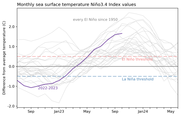
As Fall continues and winter approaches the southern region is starting to see the first signs of an El Niño affecting the cool season weather patterns. This was discussed in last week's summary when on Saturday, areas in South Texas saw as much as three inches of rain, with continuing rainfall throughout the weekend into Monday. In the latest ENSO Blog issued by NOAA, it is highlighted that this El Niño has now met the criteria to be considered a “strong” event. As the three-month average of sea surface temperatures was more than 1.5°C above the climatological normal. Now, this does not necessarily mean El Niño impacts are going to be stronger, ie. massive amounts of rain in the Southern United States or a historical cold snap. But, this does mean that El Niño impacts are more likely to be experienced now. So, the southern region is even more likely to see a wetter and cooler than normal winter thanks to this “strong” El Niño.
Weather Synopsis:
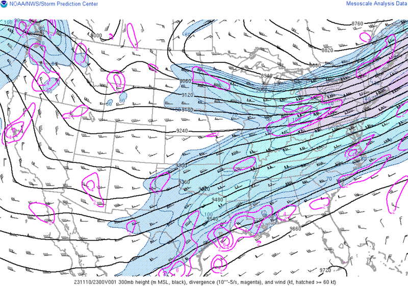
As discussed in last week's summary the jet stream is responsible for a lot of the weather in the southern region. Especially the subtropical jet stream during El Niño as it becomes amplified. This was the case last week, depicted below is the subtropical jet stream over the southern climate region. It is especially strong for this time of year thanks to our “strong” El Niño. This is what helped bring widespread showers during the weekend to Texas, Louisiana, and Arkansas.
Temperature:
Overall, November is when most of the region starts to see temperatures cooling down. Weekly cold fronts are quite common, bringing with them colder air masses from the north.
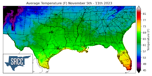
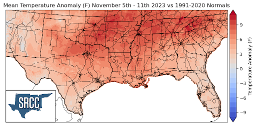
Although a cold front swept through the climate region by the end of the week, upper-level ridging throughout the southern region at the beginning of the week kept weekly average temperatures above normal. This resulted in temperature records being smashed in Texas and Arkansas last week as temperatures in North Texas up into Arkansas were up to 10 degrees Fahrenheit above normal. Daily average temperatures even reached 74 degrees in the Lower Rio Grande Valley, compared to 62 degrees the week prior. Temperatures for the majority of the region last week ranged from 68 to 58 degrees Fahrenheit.
Precipitation:
With the majority of the region being in a humid subtropical climate, rainfall is common at any point of the year. Frequently, during the fall months, cold fronts bring with them showers and thunderstorms. The boundary between the cold and warm air masses serves as a trigger mechanism for storms.
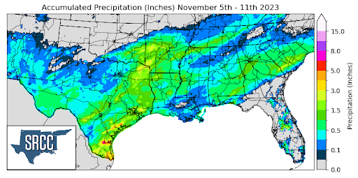
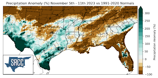
Last week's frontal passage brought minimal rain, although widespread. The larger accumulations seen toward the end of the week in South Texas and Far West Texas were thanks to a strong subtropical jet stream providing ample instability for storms, and plentiful available moisture via a tropical feed. This also led to the widespread showers seen on Friday and Saturday in Texas, Arkansas, and Louisiana. Unfortunately, though, rain totals were not near enough for areas in Southern Louisiana, Mississippi, and Tennessee, as drought continues to intensify throughout those areas.
Records/Extremes:
- 11/7/2023: College Station, TX: Set record daily high temperature of 89°F
- 11/8/2023: Wichita Falls, TX: High temperature of 91°F which sets the all-time record high for the month of November
- 11/8/2023: Childress, TX: Set record daily high temperature of 91°F
- 11/8/2023: Harrison, AR: Set record daily high temperature of 84°F
- 11/8/2023: Mountain Home, AR: Set record daily high temperature of 83°F
