10/22/2023 - 10/28/2023
Climate in the News:
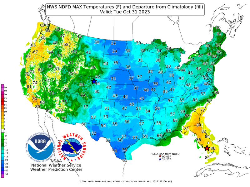
As October draws to a close, that means Halloween is only days away. This Halloween, the southern region can anticipate temperatures well below normal, due to a cold front that made its way through the southern region this past weekend. According to the National Digital Forecast Database, high temperatures on Tuesday in South Texas and Northern Oklahoma are forecasted to be 25 degrees Fahrenheit below normal. Record-low maximum temperatures are even forecasted for Boonville, AR, Laredo, TX, and McAllen, TX on Halloween. Fortunately, though, no rain is in the forecast for the southern region in the evening, meaning a cold but clear night for trick-or-treating everywhere in the region except possibly for clouds in extreme south Texas.
Weather Synopsis:
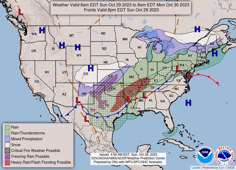
As this cold front moved through the Great Plains into the Southern United States, bringing with it a new continental polar air mass to the region, it also led to lots of showers and thunderstorms in North Texas, Oklahoma, and Arkansas, even allowing some areas of the Panhandle region to see frozen precipitation. Thankfully, the cold front made it through the region, leaving the southern climate region in a post-frontal environment that is stable and dry, which allows for dry trick-or-treating conditions Tuesday evening.
Temperature:
Overall, fall days in October are fairly comfortable across most of the region. Although, weekly cold fronts are quite common bringing with them colder air masses from the north.
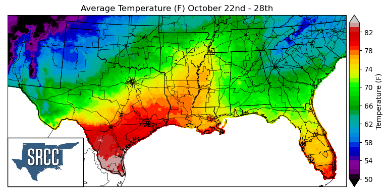
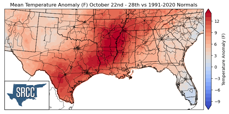
Although a cold front swept through the Northern portion of the climate region on Friday, it stalled after making it through the Dallas-Ft. Worth Metroplex and the rest of the region did not see it until yesterday. Upper-level ridging and high-pressure last week in the Southern U.S. led to above-normal temperatures for the entire region. Temperatures for the week averaged as much as 15 degrees Fahrenheit above normal in Arkansas, Louisiana, and Western Mississippi. Daily average temperatures even reached 85 degrees in the Lower Rio Grande Valley. While the temperature for the majority of the region ranged from 80 to 65 degrees Fahrenheit.
Precipitation:
With the majority of the region being in a humid subtropical climate, rainfall is common at any point of the year. Frequently, during the fall months, cold fronts bring with them showers and thunderstorms. The boundary between the cold and warm air masses serves as a trigger mechanism for storms.
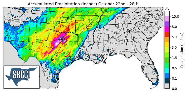
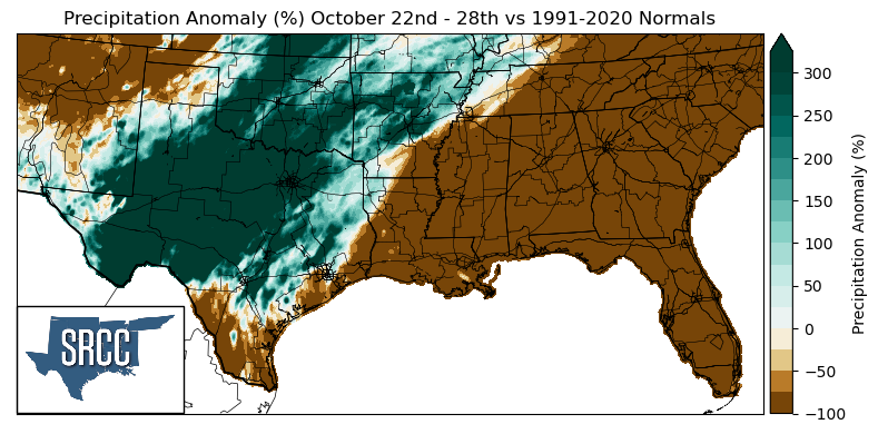
For the first time in a couple of weeks Texas and Oklahoma were finally able to experience widespread precipitation due to the abundant moisture that was advected into the region by the remnants of Post-Tropical Cyclone Norma and showers associated with the stalled front late in the week. Ample amounts of moisture led to precipitation totals three times greater than normal throughout West Texas, Central Texas, Oklahoma, and parts of Central Arkansas. This led to weekly accumulations of up to 15 inches of rain near Hico, TX. Unfortunately, though, the eastern states of the southern climate region were not as lucky. In South Texas, Louisiana, Mississippi, and Tennessee precipitation anomalies were 100% below normal.
Records/Extremes:
- 10/24/2023: College Station, TX: Tied the Record High Minimum Temperature at 75°F
- 10/25/2023: Wynnewood, OK: Tornado touchdown, no damage reported
- 10/26/2023: Somervell County, TX: 8.22 inches of rain via CoCoRaHS submission
- 10/27/2023: Montgomery County, TX: 9.23 inches of rain via CoCoRaHS submission
- 10/28/2023: Kaufman County, TX: 10.59 inches of rain via CoCoRaHS submission
