10/15/2023 - 10/21/2023
Climate in the News:
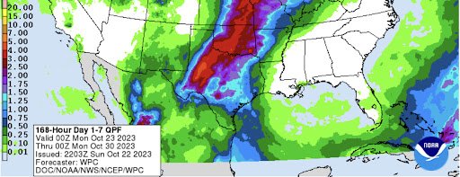
A shift in the upper-level pattern, discussed below, is expected to bring significant amounts of rain to the Southern Plains this week, leading to much of Texas, Oklahoma, and Western Arkansas expected to see above-normal precipitation totals for the week. Outlined in the 7-Day Total Precipitation forecast, by the Weather Prediction Center areas in West-Central Texas up into Central Oklahoma can expect to see up to 5 inches of rain! These areas are in need of rain as it has been 2 to 5 weeks since many areas in Central Oklahoma received more than a quarter of an inch of rain. Forecasted widespread precipitation in Texas and Oklahoma should help drought conditions continue to improve in the two states. While a lack thereof in Mississippi and Tennessee will likely lead to continuing drought development. To see how this plays out in terms of drought conditions, check back every Thursday to read our Weekly Drought Update.
Weather Synopsis:
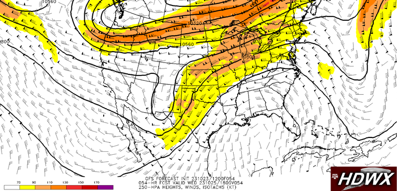
Depicted below is the Global Forecast System’s (GFS) forecasted upper-level winds for Wednesday afternoon. In the image, we can see an upper-level trough lifting out of New Mexico, as well as fast upper-level winds over the Southern Plains. There will also be plentiful amounts of moisture advecting into the region due to decaying Post-Tropical Cyclone Norma in Mexico. The combination of all these factors makes a great environment for storms and especially flash flooding due to large amounts of moisture in the atmosphere combined with drought conditions on land.
Temperature:
Overall, fall days in October are fairly comfortable across most of the region. Although, weekly cold fronts are quite common bringing with them colder air masses from the north.
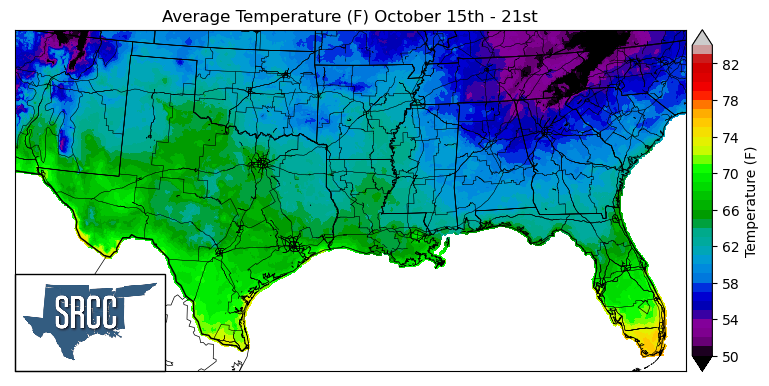
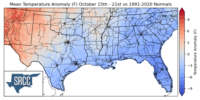
A cold front from the week prior left the beginning of last week much colder than normal for the southern region. Another cold front did pass toward the end of the last workweek, but this cold front did not lower temperatures, only dewpoints, drying things out. This allowed for some record-breaking heat into the weekend as without a cloud in the sky, daytime temperatures were able to get fairly high. This also led to wide diurnal temperature differences by the end of the week allowing as much as a 40-degree diurnal range in South-Central Texas. Looking at mean temperatures for the week, temperatures were slightly above normal in West Texas, the Panhandle region, and Western Oklahoma. But, below and near-normal temperatures were experienced in the rest of the southern region, leading to daily average temperatures ranging from 70 to 58 degrees Fahrenheit for the majority of the region.
Precipitation:
With the majority of the region being in a humid subtropical climate, rainfall is common at any point of the year. Frequently, during the fall months, cold fronts bring with them showers and thunderstorms. The boundary between the cold and warm air masses serves as a trigger mechanism for storms.
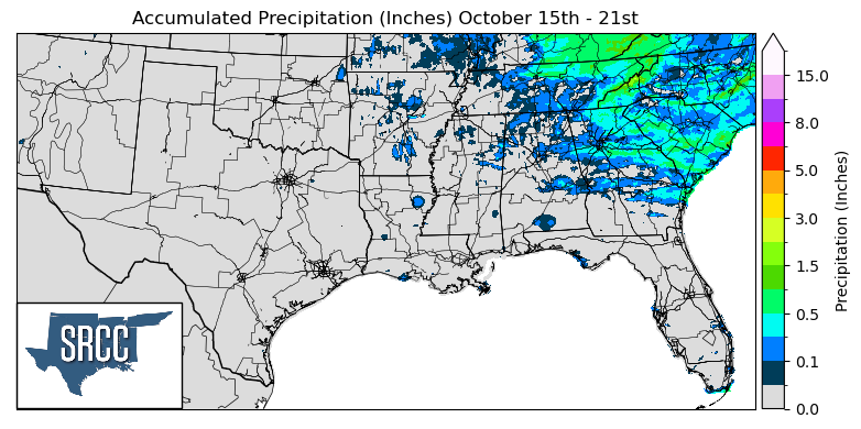
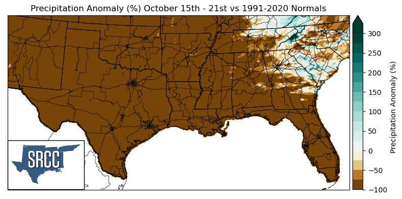
The majority of last week the climate region spent it in a post-frontal environment, leaving very little available moisture for storms. Low dew points throughout the region led to clear and sunny days much of the week. Therefore, almost all of the climate region was unable to receive as little of a trace of precipitation last week. The only areas able to receive any precipitation were the Great Smoky Mountains in Eastern Tennessee, due to terrain-initiated showers.
Records/Extremes:
- 10/17/2023: Crockett, TX: Tied Record Daily Low Temperature at 37°F
- 10/19/2023: El Paso, TX: Tied Record Daily High Temperature at 90°F
- 10/18/2023: Midland, TX: Record Daily High Temperature at 95°F
- 10/20/2023: College Station, TX: Record Daily High Temperature at 97°F, also the new #1 hottest temperature this late in the year
- 10/21/2023: Borger, TX: Record Daily High Temperature at 93°F
