10/01/2023 - 10/07/2023
Climate in the News:
Heavy rainfall and flash flooding were observed in Texas and Oklahoma last week. These were associated with severe thunderstorms and an advancing cold front. Many areas of Central and North-Central Texas are at an increased risk for flash flooding due to widespread extreme drought conditions. This is because the ground is very dry and that water fails to infiltrate into the ground and flows over land instead. It is important to respond accordingly when a flash flood occurs. The National Weather Service recommends you, “do not cross flooded roadways or approach inundated areas as water may still be rising.” Remember “Turn around don’t drown”.

Weather Synopsis:
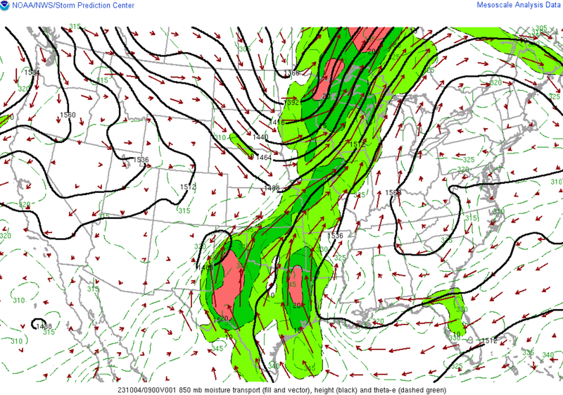
Surface and low-level winds last week were advecting moisture from the gulf up into the Southern Plains, as shown by the map below. This available moisture combined with a cold front that passed through the region mid-week allowed for ample conditions for prolonged and heavy rainfall. Which was seen in many areas of Texas and Louisiana.
Temperature:
Overall, fall days in October are fairly comfortable across most of the region. Although, weekly cold fronts are quite common bringing with them colder air masses from the north.
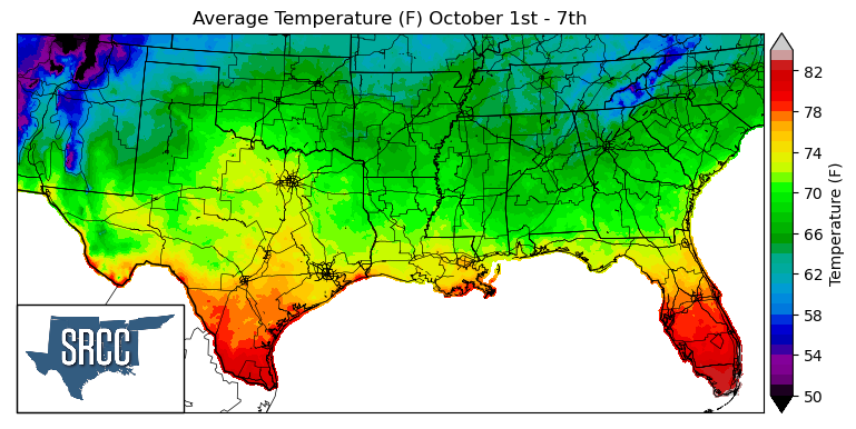
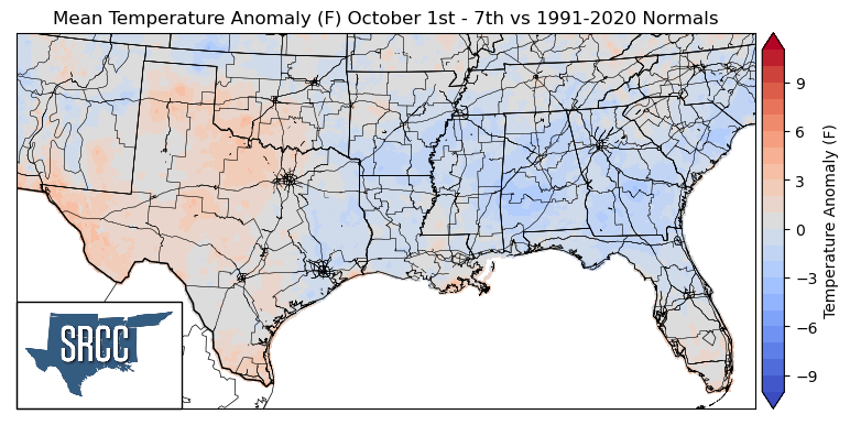
As October starts, Fall-like and seasonal temperatures were back last week in the southern climate region. An upper level trough dug down into the region mid-week bringing with it a colder air mass. This brought below average and near normal temperatures to the majority of the region. Where temperatures were slightly above normal in Far South Texas, daily average temperatures reached 83 degrees Fahrenheit. In contrast, in East Texas, Oklahoma, Arkansas, Louisiana, Mississippi, and Tennessee below and near-normal temperatures were experienced, leading to daily average temperatures ranging from 72 to 60 degrees Fahrenheit for the rest of the majority of the southern region.
Precipitation:
With the majority of the region being in a humid subtropical climate, rainfall is common at any point of the year. Frequently, during the fall months, cold fronts bring with them showers and thunderstorms. The boundary between the cold and warm air masses serves as a trigger mechanism for storms.
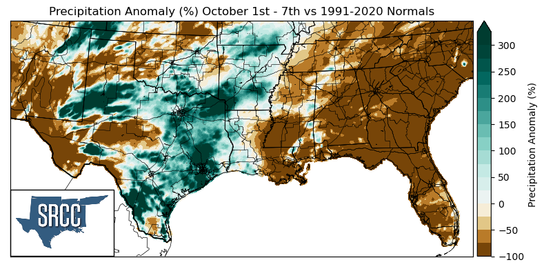
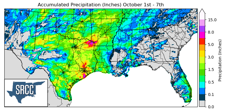
Multiple cold fronts last week along with dryline initiated thunderstorms, brought lots of rain to areas of Texas, Oklahoma, and Arkansas. Thanks to all these storms, East Texas, Central Texas, Oklahoma, Louisiana, and Arkansas were able to all receive widespread precipitation last week. The ArkLaTex region saw the most rain last week with up to 8.0 inches of accumulated precipitation for the week in Texarkana.
Unfortunately, not all of the climate region was lucky enough to receive widespread precipitation. When comparing precipitation totals last week to climatological normals, precipitation anomalies of -100% were experienced at a large scale in Southern Mississippi and Tennessee.
The areas that witnessed above-average precipitation compared to normal were primarily in Texas and Oklahoma. Some of the largest precipitation anomalies experienced were in Northeast Texas, the South Texas Panhandle, and South Texas, where precipitation was about three times normal.
Records/Extremes:
- 10/1/2023: Fort Bliss, TX: 73 mph wind associated with a downburst
- 10/4/2023: Hurlwood, TX: 3.0 inch hail reported
- 10/4/2023: Frederick, OK: 85 mph wind gust associated with a severe thunderstorm
- 10/5/2023: Palacios, TX: 75 mph wind gust associated with a severe thunderstorm
- 10/5/2023: Bowie County, TX: 10.76 inches of rain via CoCoRaHS submission
