07/21/2024 - 07/27/2024
Climate in the News:
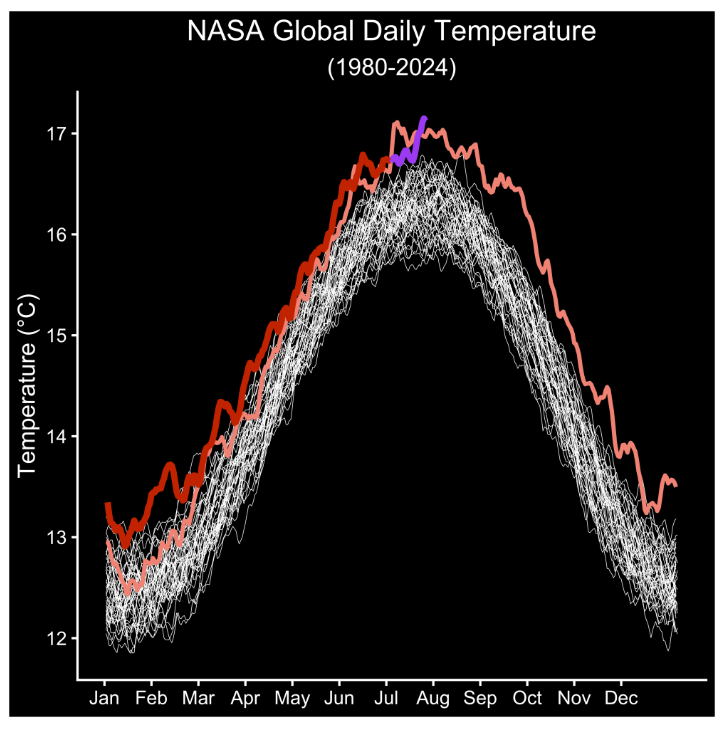
The Earth’s hottest day on record was measured this week on Monday, July 22nd, according to a NASA analysis of global daily temperature data. Sunday and Tuesday were record-breaking warm for the planet, but these values exceeded the temperature record set on those dates. As part of a long-term warming trend in temperatures on our planet, the past 13 consecutive months yielded the highest monthly average temperatures on record. The past two weeks of July have been fierce in heat, according to NASA Administrator Bill Nelson. The month so far started cooler than July 2023, then significantly rose to peak at a global daily temperature of 62.88℉, climbing just higher than last year’s high temperature of 62.73℉ set on July 6th. The record is still preliminary as various climate models are being utilized to verify observations.
Weather Synopsis:
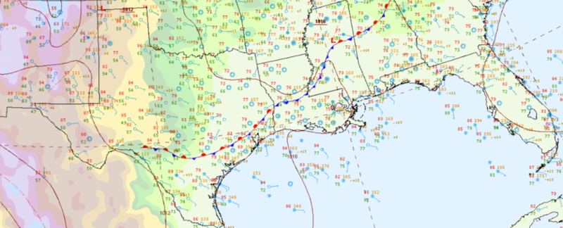
A classic stationary front draped along the coasts of Texas, Louisiana, and Mississippi caused flash flood emergencies in the Southern Region at the beginning of the week. A low pressure system associated with the front moved slowly and was stagnant at times, and a high pressure in the Gulf of Mexico brought an increased flow of warm and moist air. A balancing act between clashing cool, dense air and hot, buoyant air remained until Thursday. A process called Isentropic Upglide occurred as the stationary cool air allowed warm and moist air to continuously lift over, condense into clouds, and evolve into thunderstorms that continuously developed and trained further inland. Thunderstorms were frequent throughout the week but became isolated and affected inland states towards the end of the week as the front weakened and moved east and away from the Region.
Temperature:
Climatologically, July is the hottest month for most of the Southern Region. High average temperatures around 80℉ are typically consistent daily throughout the Region. The latter half of the month marks the beginning of the Southern Region’s peak heating of the year and the hottest for Tennessee, Arkansas, Mississippi, Louisiana, Oklahoma, and some parts of Texas.
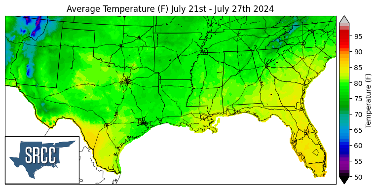
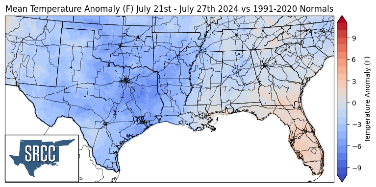
While this week’s global temperatures soared, cooler temperatures blanketed the Southern Region. Texas, Oklahoma, Arkansas, and northern Louisiana experienced much cooler-than-normal temperatures, the week’s average temperatures dropping to 6℉ below the thirty-year average in East Texas. Meanwhile, Tennessee, southern Louisiana, and Mississippi recorded temperatures much closer to normal. This week’s summertime relief is credited to a cooler air mass that approached the Region late last week and stalled over the western portion of the Southern Region. As previously described, the clash between cooler air and warm air flowing from the Gulf of Mexico further cooled the Region, providing cloud cover and generating rain-cooled air. As a result, the week’s average temperatures peaked at 86℉ along the Rio Grande River in Texas, while the rest of the Region averaged at or below 80℉.
Precipitation:
With most of the Southern Region in a humid subtropical climate, rain falls at any time of the year. By the end of July, rainfall tends to concentrate far east of the Southern Region’s coastline, while rainfall inland still occurs infrequently. Due to a steady stream of moisture from the Gulf of Mexico, isolated pop-up thunderstorms, tropical disturbances, and sea breeze convection most commonly contribute to the Southern Region’s rainfall accumulations during the summer.
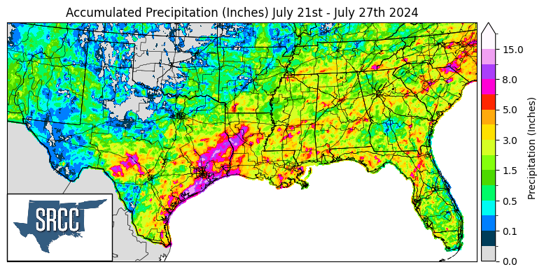
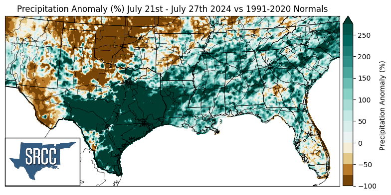
This week, precipitation was widespread and abundant in the Southern Region. Rainfall was most impactful for southeast Texas cities, where over 11 inches of rain fell over three days. The Sunday through Tuesday’s isentropic upglide event raised the 2024 rainfall totals for Houston and College Station, TX, to nearly match a year’s worth of rainfall in just six months. As of Tuesday, precipitation in College Station totaled 38.36 inches in 2024, which places this year as the second-highest rainfall year to date (Jan 1 - July 23). The Llano River in Texas received headlines for its flood risk following heavy rainfall at the beginning of the week. As stormwater drained into the river by Tuesday, the river rose to 17 feet and caused moderate flooding. As a result of this week’s persistent stalled front, rainfall accumulations soared to over 250% precipitation anomalies throughout the Region for the last days of July.
