06/30/2024 - 07/06/2024
Climate in the news:
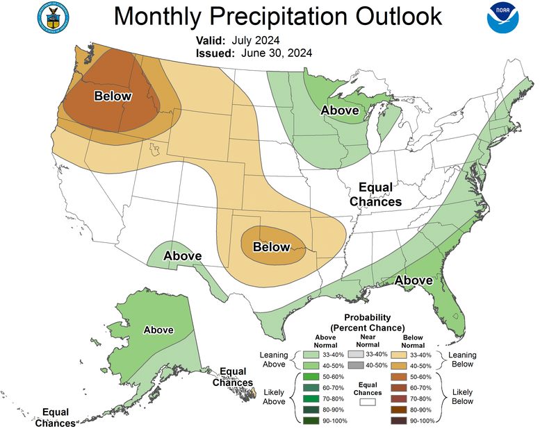
The Climate Prediction Center’s precipitation outlook for July reflects the growing influence of La Niña in this summer’s forecast. As of June 2024, the ENSO (El Niño-Southern Oscillation) forecasting team predicted a 65% chance that La Niña will arrive by July-September. El Niño and La Niña have little impact on the United States' summer climate. However, each side of the oscillation supports or inhibits tropical cyclone activity, depending on the location. La Niña in the summer supports an active Atlantic Hurricane season. The atmospheric circulation that results from La Niña promotes cooler than average temperatures on our side of the Pacific and strong winds aloft toward the area, interfering with any potential hurricane formation and inhibiting most convection (thunderstorms) in the Pacific Ocean. At the same time, its circulation supports convection in the Atlantic.
Current conditions indicate a neutral phase is present, and the development of La Niña is a waiting game for July. La Niña's clearest indicator is cooler-than-average sea surface temperatures in the eastern Pacific. As of mid-June, surface temperatures were close to average while a deeper pool of cool water lurked, waiting to well up to the surface. For the United States, this neutral phase typically means average conditions. The probability of precipitation in the south this month is equally leaning above-normal and staying near-normal. However, much of Texas, Oklahoma, Arkansas, and the Northwest is forecasted to lean toward drier than normal conditions, with up to a 60% chance of it in the Pacific Northwest. A more rapid development of La Niña this month may amplify these chances, especially along southern and western coasts.
Weather Synopsis:
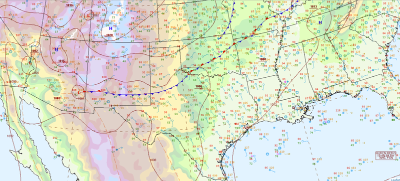
While the country celebrated Independence Day on Thursday, severe weather was brewing in the Southern Region. A low-pressure system in Minnesota draped a cold front southward, extending across west Oklahoma and the Texas panhandle in the morning. By the evening, this cool air mass traveled southward by a new family of low-pressure systems, and storms began to fire in west Texas as another area of low pressure formed there. The front moved slowly and was often stationary throughout the evening. In particular, a strong line of thunderstorms formed southwest of the Texas panhandle and affected the area for almost 4 hours as storms continuously formed and trained over the stalled front.
Significant reports:
- Landspout in Collingsworth, TX
- 80 mph wind gust in Hockley, TX
- 81 mph wind gust in Pontotoc, OK
Temperature:
Climatologically, July is the hottest month for most of the Southern Region. High average temperatures around 80℉ are typically consistent daily throughout the Region. Some northern portions of Tennessee and southern portions of Texas stray 10 degrees cooler and warmer, respectively, compared to the rest of the Southern Region. The jet stream's location is the farthest north this time of the year, allowing extensive heat and moisture to deposit in the Region from the tropics.
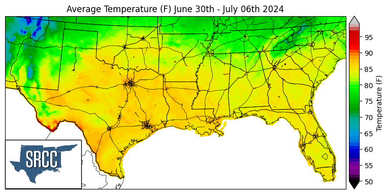
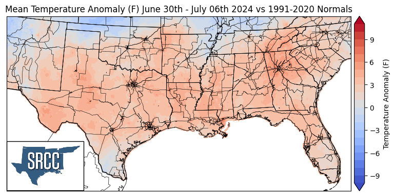
The Southern Region experienced another warm week as the calendar turned to July. Most of the Region averaged 85℉, and most of Texas and Louisiana approached 90℉ averages. Large portions of the region received warmer than normal temperatures, most notably in east Tennessee and west Texas. Anomalous heat and humidity broke records in Lawton, OK, where nighttime temperatures did not cool lower than 77℉ and 78℉ on June 30th and July 2nd, respectively. However, the cold front that brought severe weather to the Southern Region on July 4th also ushered in cooler temperatures to Oklahoma and the Texas panhandle by the next day. Wichita Falls, TX, recorded a maximum temperature of 77℉ - 3 degrees lower than the previous record for the date, from 1958. Northern parts of Arkansas, Tennessee, west Texas, and South Texas also recorded cooler-than-average temperatures this week. Cloud cover and rainbands from approaching Tropical Storm Beryl moderated temperatures in south Texas.
Precipitation:
With most of the Southern Region in a humid subtropical climate, rain falls at any time of the year. In July, rainfall tends to concentrate by the Southern Region’s coasts, while rainfall inland still occurs infrequently. A steady stream of moisture from the Gulf of Mexico, influence from tropical disturbances, and sea breeze boundaries most often trigger thunderstorms in the summer in the Southern Region.
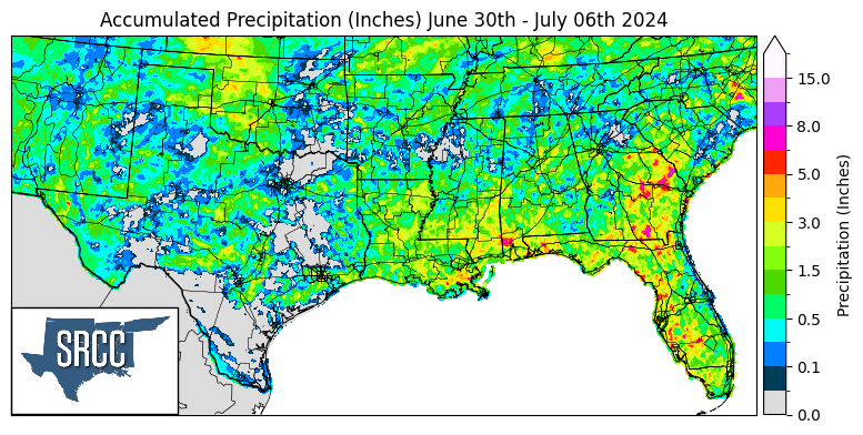
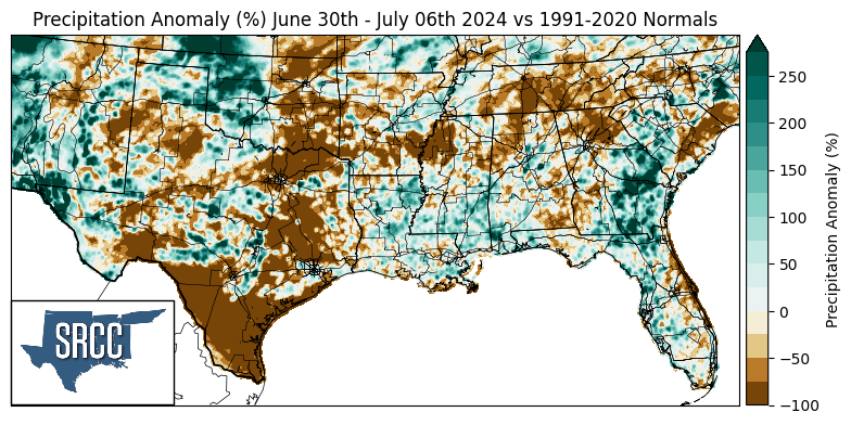
Precipitation was widespread in the Southern Region this week as multiple cold fronts and outflow boundaries initiated lines of thunderstorms. Many locations at the beginning of the week held high precipitable water values which caused high rainfall rates in most strong thunderstorms. Throughout the week, outflow from storms produced north of the Region produced lines of thunderstorms in Arkansas, Tennessee, and Oklahoma. On Wednesday, a stationary (baroclinic) boundary extended into northeast Oklahoma from the north, producing isolated thunderstorms and supercells. On July 4th, the cold and stationary front in Oklahoma and Texas initiated a line of thunderstorms with strong outflows, which allowed it to sustain as it moved farther east. Short-lived and isolated severe thunderstorms with high rainfall rates also occurred in northwestern Tennessee. Furthermore, the highest rainfall accumulations in the Southern Region occurred in coastal Louisiana and Mississippi. Almost daily morning showers and thunderstorms led to 6+ inches of rainfall over the week.
