06/23/2024 - 06/29/2024
Climate in the News:
The 2024 Atlantic Hurricane season’s second storm developed into a major hurricane and raised alarms due to its unprecedented strength for its time of the year and location. Hurricane Beryl set the record for earliest Category 4 (peak sustained winds exceeding 130 mph) and Category 5 (winds 157+ mph). It is the strongest Atlantic hurricane on record for June and July! For context, the first major hurricane tends to form in late August or early September. Additionally, Beryl took an extraordinary 48 hours to strengthen from an unnamed depression (winds 38 mph or less) to a Category 4. It was the earliest storm to undergo such rapid intensification and develop and maintain a track as far east and south in the Atlantic Basin.
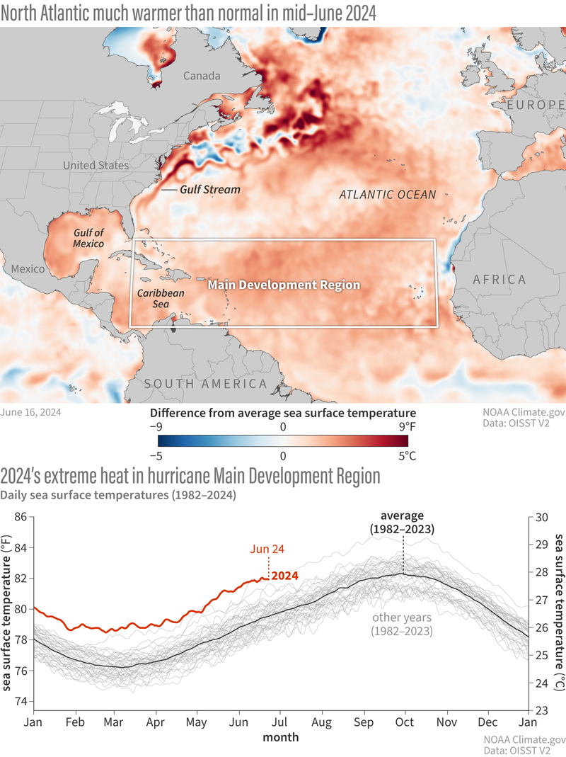
A storm like Beryl is not a complete surprise to atmospheric scientists. NOAA’s recent ENSO blog describes what makes this year’s season favorable for extraordinary tropical activity in the Atlantic. Sea surface temperatures in the Atlantic basin have been at record warm levels in 2024, but anomalously warm conditions have persisted for decades in this Main Development Region (outlined in white below). However, this May’s observed surface temperatures were so warm that they resembled August temperatures. Combined with the end of El Nino, the forecasted development of La Nina by the peak of the hurricane season, and an expected stronger-than-normal African monsoon, many factors favor an active season this year.
Weather Synopsis:
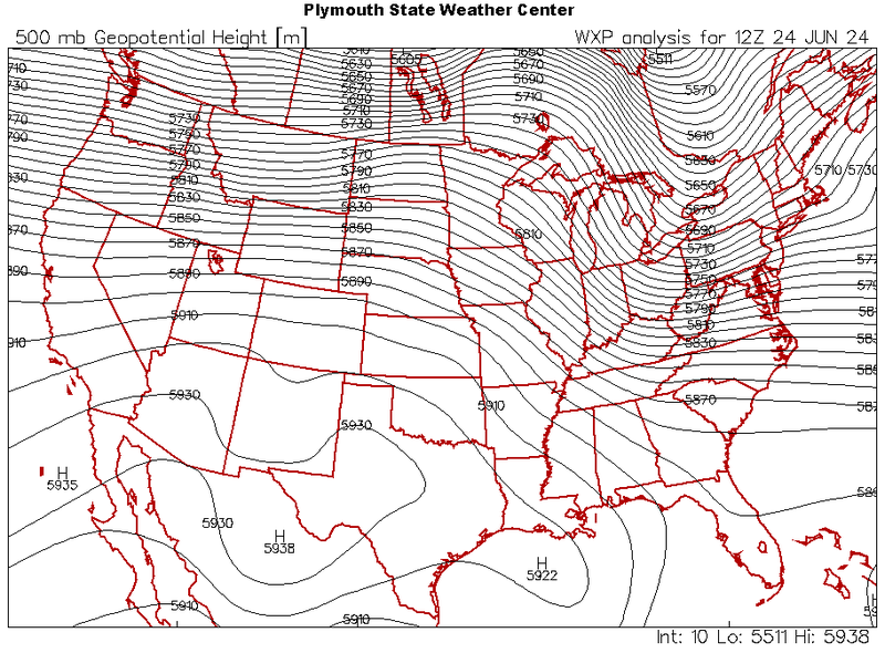
Last week consisted of excessive heat warnings and widespread thunderstorms for every state in the Southern Region. The atmosphere’s large-scale flow played a key role in both scenarios. In the summer, the atmospheric flow above the Southern Region is dominated by strong ridges formed by our deep warm layer of air. A ridge traps surface heat from mixing higher up in the atmosphere and forces air aloft to sink, allowing the surface to warm even further. This was the main atmospheric setup over the Southern Region last week that allowed many areas to hit their first 100-degree day of the summer, despite multiple days of showers and thunderstorms.
Areas that hit their first 100-degree day this week:
Chattanooga, TN; Mount Ida, AR; Oklahoma City, OK; Baton Rouge, LA; Shreveport, LA; Natchitoches, LA; Dallas-Ft. Worth, TX; Austin, TX; Texarkana, TX; Greenville, MS; Columbus, MS; Greenwood, MS; Meridian, MS; Hattiesburg, MS
Temperature:
Climatologically, June is the third-hottest month of the year for the Southern Region. As the month comes to an end, high average temperatures around 80℉ are typically consistent daily throughout the region. Some northern portions of Tennessee, Texas, Oklahoma, and Arkansas may still stray about 10 degrees cooler than the rest of the Southern Region. On average, most areas in the Southern Region have yet to experience their first hundred-degree day of the year, and its occurrence is typically rare near the Gulf of Mexico.
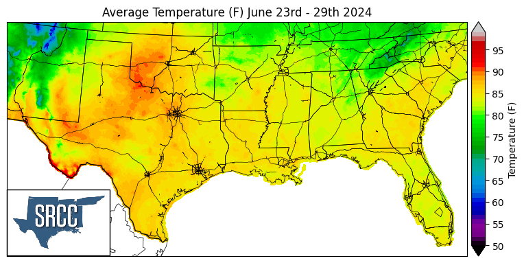
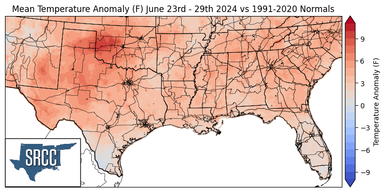
Hot temperatures returned to the Southern Region this week once slightly drier conditions were restored as Alberto’s remnants moved westward last Saturday. The western portion of the region favored temperatures 10℉ above normal, but further east and south, temperatures were near or slightly below normal. The highest departures were felt in western Oklahoma and Texas, where temperatures averaged up to 90°F for the first time this year. Many stations in this area reported 100-degree maximum daily temperatures over multiple days of the week. San Angelo, TX exceeded 100 degrees each day this week, peaking at 106°F on Friday. Unfortunately, high daytime heat and anomalous moisture led to warming nights. Following multiple 100-degree days, the low temperature recorded in Lawton, OK, on Friday morning was 79°F, setting a record for the warmest low temperature for this date. The next nights also yielded near-record and record-high low temperatures, as reported by the National Weather Service. For the rest of the Southern Region, where daily temperatures did not reach 100°F, the heat index exceeded it. The remaining moisture carried in by Alberto and large-scale flow from the Gulf of Mexico helped moderate daytime temperatures in the east and south.
Precipitation:
With most of the Region in a humid subtropical climate, rain falls at any point of the year. By the end of June, rainfall tends to concentrate by the Southern Region’s coasts, while rainfall inland becomes infrequent. A steady stream of moisture from the Gulf of Mexico, influence from tropical disturbances, and sea breeze boundaries most often trigger thunderstorms in the Region.
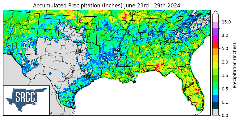
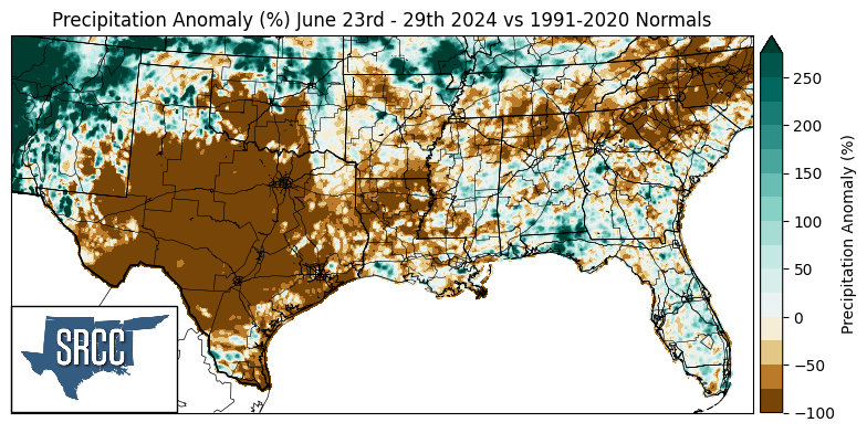
Precipitation was relatively scarce over the Southern Region this week. Tennessee and Mississippi were the only states that experienced rainfall throughout most of the state. Heavy rain was localized and concentrated in the north and coasts of the Region. A sea breeze boundary triggered thunderstorms in Louisiana and Mississippi, resulting in 8.45 inches of precipitation recorded by a CoCoRaHS station in Belle Chasse, LA. Early in the week, flow from a high-pressure system near the Rocky Mountains caused storm systems to move into the Southern Region from the northwest. On other days, outflow boundaries from storms up north produced more thunderstorms in the Region, especially in Tennessee and Oklahoma. A deep high-pressure system prevented storms from entering most of Texas, as storms that occurred crept around areas of high pressure and moved through the Region steered by the clockwise flow around each high.
