06/16/2024 - 06/22/2024
Climate in the News:
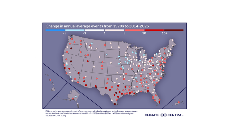
There are now more dog days of summer, according to a report and article by Climate Central. Hot days accompanied by hot nights have become much more frequent over the past ten years compared to the 1970s. The South has seen the greatest change, as depicted in the graphic below. Texas, Oregon, California, and Nevada are among the states that recorded 10+ more days on average of extremely hot temperatures (day and night) in the summer.
Does this mean that nighttime temperatures have increased? Yes, since the period of record in 1895. The coolest temperatures in a day usually occur overnight before or just after sunrise and are denoted as minimum temperatures. Since 1850, average minimum temperatures each year in the contiguous U.S. have been on a warming trend. The highest average temperatures were recorded recently in the 2020s and 2010s.
Warming nighttime temperatures, and more frequent hot ones, are often paired with humid nights. Hot daytime temperatures cause liquid water to evaporate. As the sun sets, temperatures slightly cool causing humid nights. The additional water vapor during the night blocks the earth’s heat from escaping to space, enhancing heat and mugginess. Thus, warmer days often cause warmer nights, making summertime more uncomfortable and dangerous as our bodies get less rest from heat stress.
Weather Synopsis:
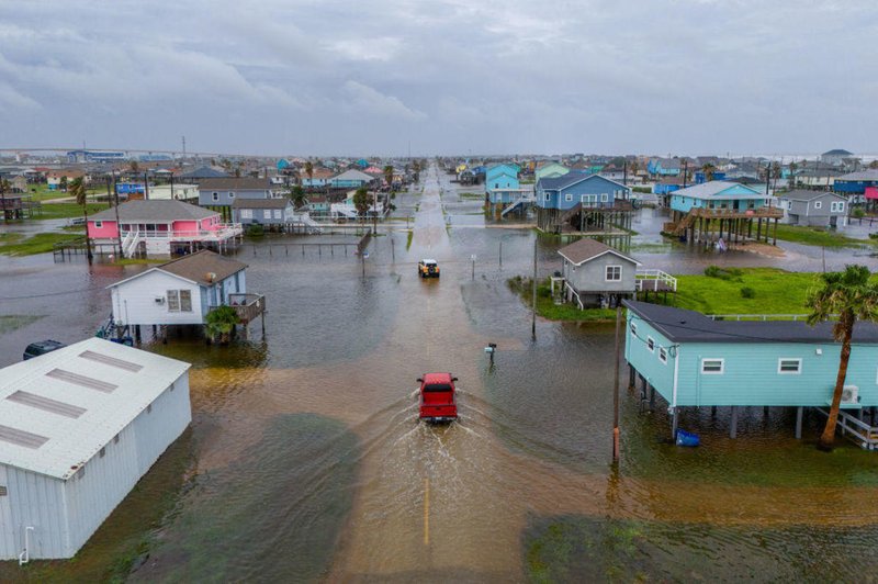
Tropical storm Alberto made landfall in Northeast Mexico early morning on Thursday, June 20th, devastating parts of Mexico due to heavy rain, damaging winds, and destructive storm surge. Before landfall, Alberto’s large structure caused its winds to extend nearly 400 miles north of its center. Aided by high tide and pressure differences as Alberto approached landfall, a wide area of storm surge occurred along Southern Region coasts. On Wednesday, water levels rose to 4 ft in South Texas and significantly impacted as far north as Louisiana coasts.
Significant water levels recorded:
- Surfside Beach, TX, south of Galveston Island, recorded 4 ft of surge.
- Galveston Bay recorded its fourth-highest water level since 1996 at 3.71 ft
- Behind surges from Hurricanes Ike and Nicholas and Tropical Storm Beta.
- Corpus Christi Bay recorded its second-highest water level since 2004 at 3.45 ft
- Port Arthur, TX, located by the Louisiana-Texas border, recorded its fourth-highest water level since 2005 at 2.77 ft.
- Port Isabel recorded 3 ft of surge.
Alberto’s circulation dissipated by the evening on Thursday, June 20th, but its remnants and the moisture it carried inland continued to impact rainfall for Mexico and Texas.
Temperature:
Climatologically, June is the third-hottest month of the year for the Southern Region. High average temperatures become consistent, typically at 70 to 80 degrees Fahrenheit. As the sun's heating concentrates north of the equator (at most during the summer solstice, which occurred this week on June 20), the temperature gradient across the Southern Region weakens. However, northern portions of the region still usually remain up to 10 degrees cooler than the south.
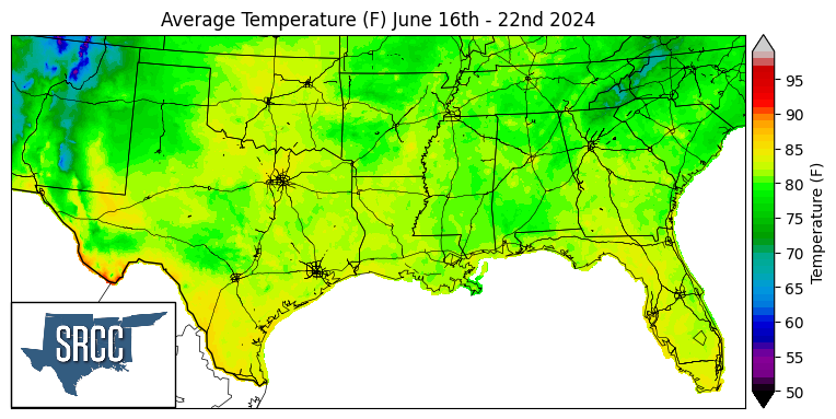
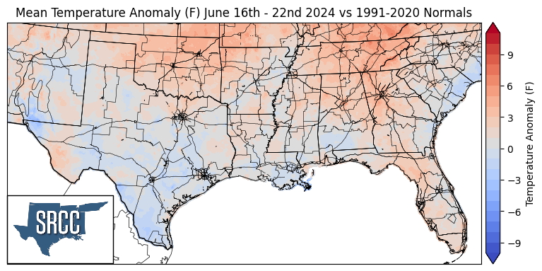
For the first time since the middle of May, average temperatures for the week in the Southern Region stayed below 90℉. Most of the region averaged 80℉, close to the long-term average for the Southern Region during June. Considering the summer solstice, average temperatures across the region should have continued the past weeks’ trend, with low 90s extending farther north. However, Tropical Storm Alberto brought cloud cover and extreme rainfall throughout the week, inhibiting daytime temperatures from even reaching the 90s over south Texas. As a result, temperatures dipped to much cooler-than-normal temperatures as the affected area averaged 85℉ over the week. Still, early in the week, when Alberto was unnamed and affecting the Yucatan Peninsula, record heat peaked in the west of the region:
- Stillwater, OK reached 101℉ on Monday, the first 100-degree day of the year for this area.
- Amarillo, TX did not cool to less than 72℉ overnight by Tuesday morning, a record-warm low temperature for the day.
- Dalhart, TX reached 102℉ on Tuesday, a record-high temperature that ties the old record from 2012.
Precipitation:
Climatologically, in the middle of June, precipitation tends to concentrate along the coastal regions of the Dixie Alley. For the Southern Region, this tends to be along east Texas to southern Mississippi. Rainfall inland remains but becomes less frequent compared to May.
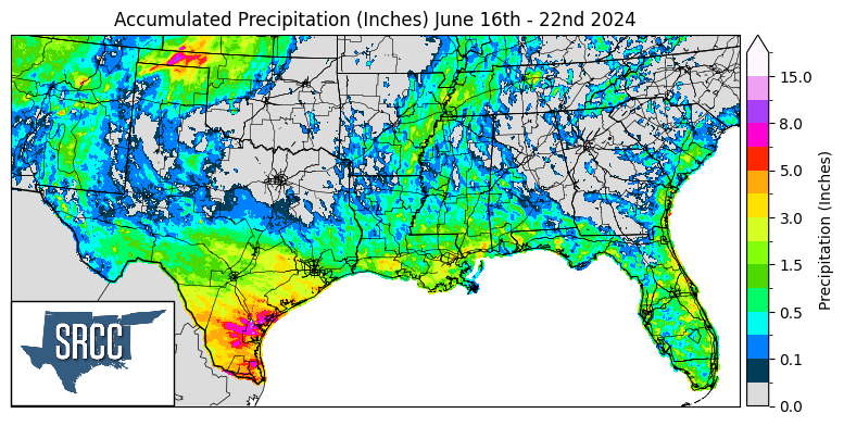
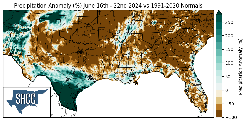
This week proved very wet for the Oklahoma panhandle, the coastal areas, and especially south Texas. Rainbands from Tropical Storm Alberto led to several days of prolonged and heavy rainfall in South Texas. From June 19th to June 21st, 10.5 inches of rain fell in Aransas County, Texas according to a report from the National Weather Service Corpus Christi office. Nueces and Refugio Counties in Texas saw slightly smaller totals, nearly 8 inches, and still experienced widespread flooding. The highest accumulation over 24 hours, 8.35 inches, occurred in Rockport, TX in Aransas County on Thursday according to a CoCoRaHS report. The same city experienced a tornado the day before, significantly damaging roofs and uprooting trees and setting up a catastrophic scenario. The rain contributed to flooding already present from storm surge and caused widespread flash flooding further inland.
Out west, a stationary front draped across the Oklahoma panhandle initiated thunderstorms that produced rainfall overnight and into the morning of June 19th. The area received more than 5 inches of rainfall, and for a CoCoRaHS station in Turpin, OK, this single event more than doubled the total rainfall it collected so far in 2024. An Oklahoma Mesonet station in Goodwell, OK, measured over 7.61 inches of rain in 12 hours, which is more than the amount the station collected for the entire year in 2022. Copious rainfall over a short period of time, especially in such a drought-affected area, made the Oklahoma panhandle prone to dangerous flash floods.
