06/09/2024 - 06/15/2024
Climate in the News:
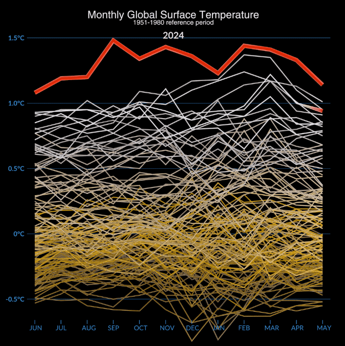
According to a NASA analysis, the Earth experienced the hottest May on-record last month. May 2024 had the highest global average temperature for the month, and so did April 2024, March 2024, February 2024, January 2024, December 2023, November 2023, October 2023, September 2023, August 2023, July 2023, and June 2023. The graphic below highlights how the past 12 months of global temperatures (subtracted from the average global temperature of the 20th century) were much higher than previous years. This difference is most obvious in June 2023 through December 2023 temperature records, especially in September when the month’s average global temperature was more than 0.5 degree Celsius higher than the previous record! The ten years prior to 2023 have been the warmest decade on record for the planet, and 2024 is well on its way to making it eleven.
Weather Synopsis:
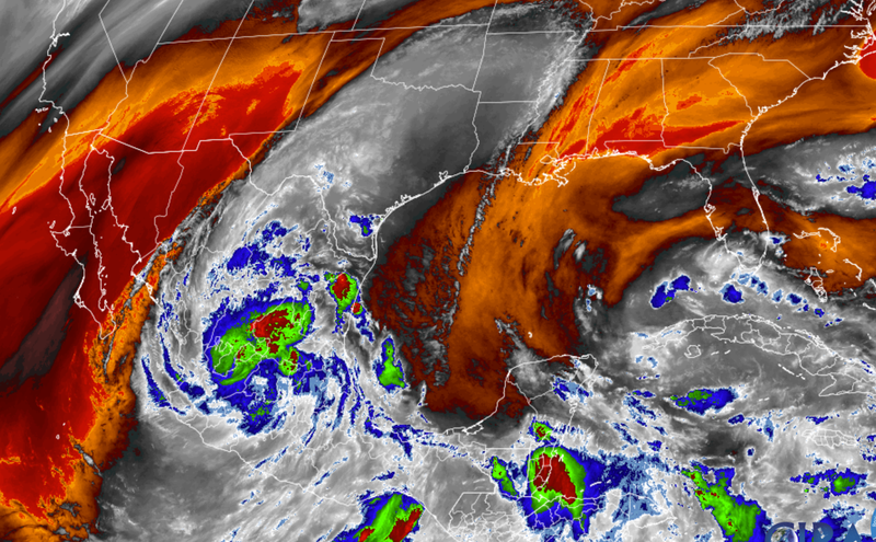
A large, rotating region of moist and convective (thunderstorm producing) air is currently affecting Central America. At the beginning of this week, this pocket contained two low pressure centers, one of which was located over the Bay of Campeche, Mexico. The whole system moved north and west, and impacted the western Gulf Coast starting Tuesday, June 18th.
Typically, tropical disturbances from southern Central America are large and need a lot of time on warm water to compact and organize into stronger storms. Since the system was forecasted to landfall within three days, the timing supported the disturbance to develop tropical storm intensity. A tropical storm is one category below hurricanes based on maximum sustained winds ranging from 39 to 73 miles per hour. In this case, maximum sustained winds peaked close to 50 miles per hour with higher wind gusts. Upon reaching tropical storm status, the system received the first name on the 2024 Atlantic Hurricane Season’s dedicated list - Alberto.
The size of the storm allowed strong winds to extend up to 290 miles outside the center, especially in its northeastern region. The size and winds directly cause dangerous storm surge, especially when combined with high tides. Accompanied by large and destructive waves, the worse-case scenario was forecasted to bring the following water heights:
- Sargent, TX to Sabine Pass, TX: 2-4 ft
- Galveston Bay: 2-4 ft
- Mouth of the Rio Grande, TX to Sargent, TX: 1-3 ft
- Sabine Pass, TX to Vermilion/Cameron Parish Line, LA: 1-3 ft
To the rest of the Southern Region, the biggest hazard Alberto carried was flash flooding due to excessive rainfall. The storm continues to transport an abundance of moisture from the tropics as denoted in gray in the water vapor imagery below. For all future hazards, information and forecast updates specific to an area can be found at the National Weather Service’s website by clicking on a location on the map, or typing in a zip code.
Temperature:
Climatologically, June is the third-hottest month of the year for the Southern Region. High average temperatures, typically at 70 to 80 degrees Fahrenheit, become consistent. As the sun's heating increasingly concentrates northward, the temperature gradient across the Southern Region (between the southernmost point of Texas and the northern portions of Tennessee and Arkansas) becomes generally even.
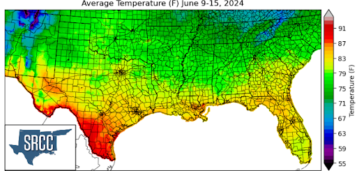
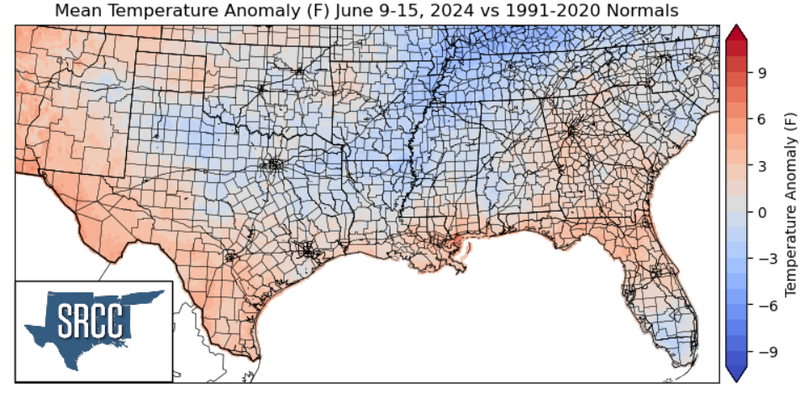
Temperatures are rising in the Southern Region. Last week, average temperatures at most coastal and southern areas rose to 85 degrees Fahrenheit and higher. This warming is significant compared to last week, especially for Louisiana and Mississippi. Hot average temperatures of low 90s spread farther into central Texas which impacted portions of San Antonio. These areas experienced 3 to 5 degrees above-normal temperatures for this time of the year. About a 20 degree temperature gradient existed in the Southern Region as northern portions stayed within the lower 70s.
Precipitation:
Climatologically in June, precipitation begins to concentrate along the coastal regions of the Dixie Alley. For the Southern Region, this tends to be along east Texas to southern Mississippi. Rainfall inland remains but becomes less frequent compared to the month of May. As the month progresses, rainfall patterns tend to shift eastward.
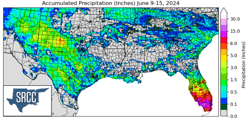
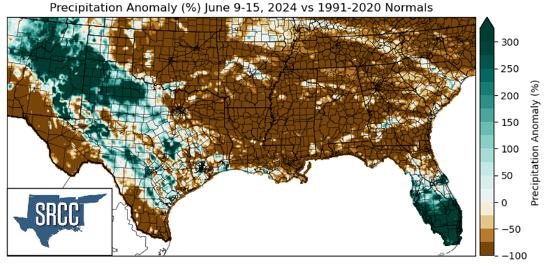
Last week, the Southern Region received widespread rainfall throughout central and west Texas. Early in the week, a low pressure system dragged a cold front through west-central Texas which eventually made its way south. Its movement was slow, and it stalled near the coast spreading from Texas to Mississippi. This slow progression brought continuous rainfall through a Southern Region classic phenomenon called isentropic upglide. Dense, cold air stalled over Texas allowed warm, moist air from the Gulf of Mexico to continuously rise over. As this air lifted while progressing toward the northwest, it formed widespread and slow-moving storms. As a result, the Texas panhandle region received about 8 inches of rainfall last week - the highest for the Southern Region. Much of the rainfall produced 300% higher accumulations than normal for this time of the year.
