05/19/2024 - 05/25/2024
Climate in the News:
The National Oceanic and Atmospheric Administration (NOAA) predicts that the 2024 hurricane season in the Atlantic basin, which starts June 1st and ends November 30th, will be above-normal. Hurricane activity may be high, as 8 to 13 are expected throughout the season. Four to seven of these storms are expected to become major hurricanes, classified within categories 3, 4, and 5 due to winds of 111 mph or higher. Overall, 17 to 25 named tropical storms are expected, which is the stage before a storm may strengthen into a hurricane, with winds of 39 mph or higher. There is high confidence in this forecast, as ocean temperatures in the Atlantic are near record-breaking warmth, and the Atlantic trade winds are weakening in strength, contributing to less wind shear. The Pacific has shown signs of La Niña conditions, which is favorable to tropical storm development in the Atlantic. This places the Southern Region at a much higher risk than last year to receive landfalling storms.

Weather Synopsis:
The Southern region experienced damaging severe weather every day last week since Tuesday, May 21st. The bulk of damage occurred on Wednesday evening, when 30 people were injured in Bell County, TX in a tornado that produced up to EF2 damage, and Saturday evening, when a fatality occured after a tornado left EF3 damage in a home in Boone, AR. Saturday’s storms were caused by a classic low pressure system that moved toward the Panhandle from the Rocky Mountains. Separate from the system, a dryline extended southward from the Panhandle. The conditions for severe thunderstorms existed in Texas, Oklahoma, and Arkansas, allowing the dryline to initiate thunderstorms that progressed eastward.
Temperature:
Generally, May is when the Region starts to see consistently warmer temperatures. Temperatures in the southern portions of the Region often start seeing daily average temperatures in the low 80’s.
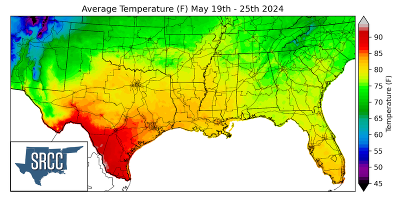
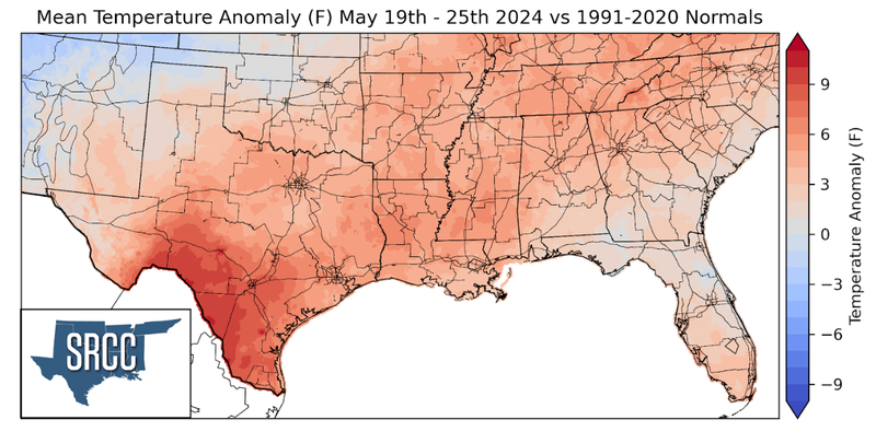
This was the case for south Texas as average temperatures climbed to high 90’s along the lower Rio Grande Valley. These high temperatures are almost 10 degrees warmer than May’s long-time average temperatures. Most of the rest of the region experienced 3 to 6 degrees above normal heat, with average daily temperatures in the 80’s.
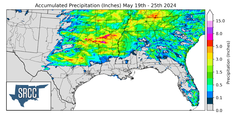
Precipitation:
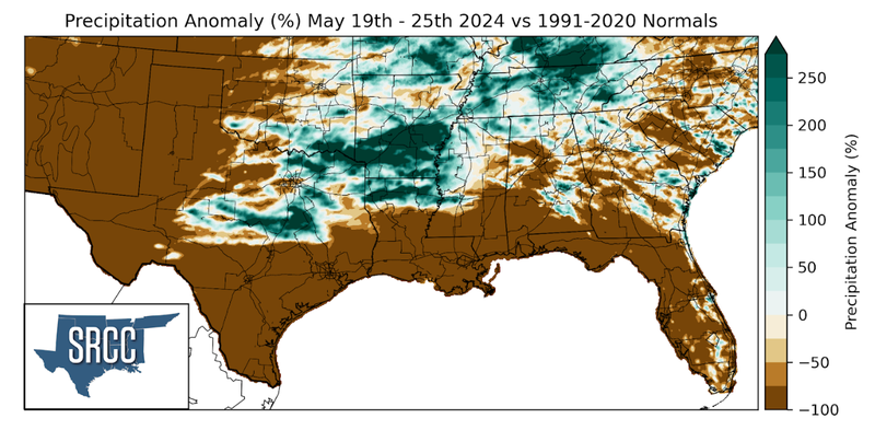
With the majority of the Region being in a humid subtropical climate, rainfall is common at any point of the year. During the spring months, storm systems are common throughout the southern portions of the Region. During May severe storm probabilities are at their highest in Oklahoma and Northeast Texas in the Southern Region. Such was observed last week as highlighted in the weather synopsis. Arkansas, however, received the highest precipitation accumulation last week, as storms tracked eastward from Oklahoma and Texas. In typical severe storm environments, storms eventually cluster together into a line of thunderstorms with a trailing region of rain as it progresses away from its source region. As a result, regions in Oklahoma and Arkansas received over 6.5 inches of rain, most notably in southern Arkansas which received over 8 inches over the past week.