September 2024
Significant Weather Events:
With the peak of Atlantic hurricane season this September the Southern Region was impacted by two landfalling hurricanes. The first storm, Hurricane Francine, formed in the Yucatan Peninsula on September 9th before shifting north-northeast. The warm waters of the Gulf of Mexico allowed Francine to strengthen to a category 2 Hurricane before making landfall in Terrebonne Parish, Louisiana on the evening of September 11th. The sustained winds at landfall were estimated to be near 100 miles per hour. The storm surge reached as high as four feet, drowning some coastal communities. After landfall, Francine tracked inland toward New Orleans, LA where it brought heavy rain and flooding to the city. Parts of the city reported as much as eight inches of rain. Francine's impacts were felt throughout the South, resulting in power outages across four states.
Hurricane Helene formed just outside the Gulf of Mexico to the east of the Yucatan Peninsula on September 23rd before quickly moving into warm Gulf waters which fed the storm Helene then moved north-northeast toward the Big Bend areas of Florida where Hurricane Helene made landfall as a major category 4 Hurricane on the night of September 26th. Helene was also a particularly large storm resulting in tropical storm-force winds being felt all the way into Eastern Tennessee. The major concern for residents of the Smoky Mountains was the rainfall. Throughout the mountains, it rained eight to ten inches. This resulted in the Nolichucky Dam nearing imminent failure on September 27th. The dam hit a record-high elevation and massive regulated releases were the only thing that kept the dam from failing. The regulated releases and extreme rainfall caused devastating flooding in Eastern Tennessee. Flooding caused landslides and mudslides which took out portions of highways. Many roads are still unpassable. Power has been completely wiped out and residents are on a boil and converse water notice. This storm's devastation was felt throughout the Southeast United States. As of the morning of October 2nd, 161 people have died across six states (Florida, Georgia, South Carolina, North Carolina, Virginia, and Tennessee) according to Fox News. Search and rescue is still ongoing with hundreds still missing. If you can and would like to help, please follow these links: https://www.usatoday.com/story/news/nation/2024/09/28/how-to-help-hurricane-helene/75431425007/ and https://www.cnn.com/us/how-to-help-helene-storm-victims-iyw.
Temperature:
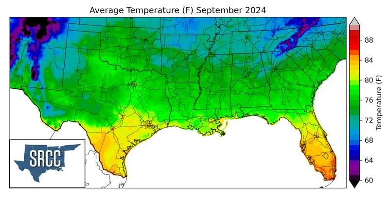
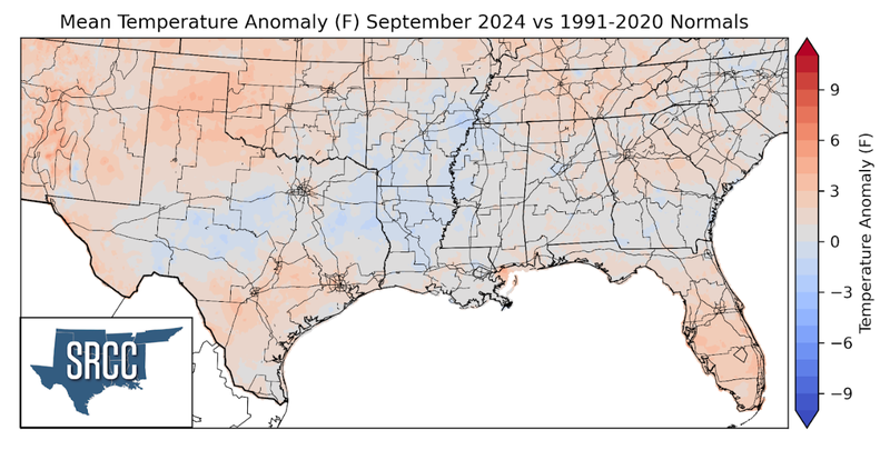
Temperatures were slightly above or near normal for the majority of the Region last month, with the exception of Central Texas, Northern Louisiana, and near Memphis, TN. Temperatures were mild to start September as a strong cold front swept through the Region, giving residents a preview of Fall. Temperatures were similar the following week as another cold front came through. Weekly cold fronts are characteristic of Fall but, by mid-month the region was experiencing a “second-summer”. Temperatures soared across the Region as an upper-level high-pressure system dominated the weather pattern. September rounded out with some slightly above-normal moderate temperatures. This all resulted in September’s average temperature for the Southern Region ranging from 72 to 80 degrees in most places. The coldest monthly temperatures for September were found in the Great Smoky Mountains along the Tennessee-North Carolina border where temperatures were as cool as 66 degrees Fahrenheit.
Precipitation:
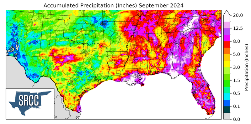
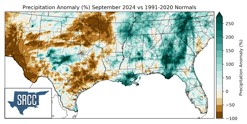
In September precipitation totals varied widely across the Region. Below-normal precipitation totals were found in Far West Texas, Southeast Texas, Oklahoma, and Western Arkansas. Generally, these areas only received a maximum of 1.5 inches of rain leaving soils very dry. But, West-Central Texas, Southeast Louisiana, Central Mississippi, Northeast Arkansas, and Eastern Tennessee all saw precipitation totals above normal last month. Notably, the Big Country (Abilene-San Angelo area) saw rainfall totals three times normal. This resulted from a large slow-moving storm system that passed through the area on September 2nd. From this most of the Big Country saw 4 inches of rain, but some isolated areas, such as Callahan County received ten inches in a 24-hour period according to a CoCoRaHS report. Much of the rain brought to the region was from Hurricane Francine and Helene as discussed above. Throughout the month though, frequent sea-breeze-initiated thunderstorms move inland near the Gulf coast. Rainfall totals along the coast were quite high in the Southern Region, at least 8 inches in most areas. Precipitation totals varied vastly throughout the Region, although the eastern portion of the Region saw a minimum of 4 inches. Rainfall overall followed the expected pattern that one would expect given tropical influences.
Drought:
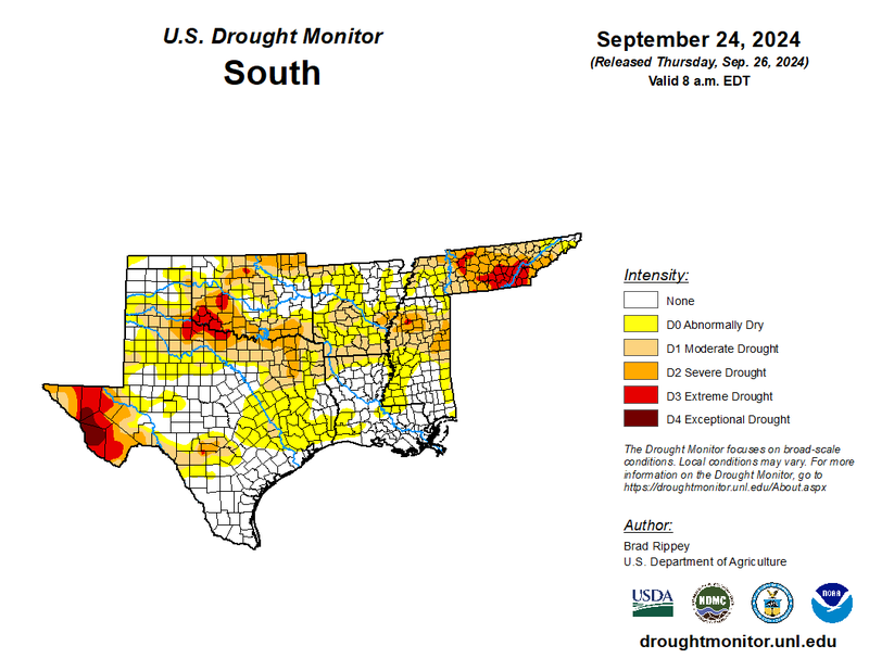
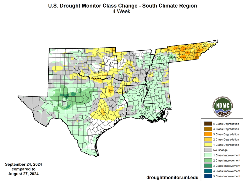
The Southern Region saw more rainfall and cooler temperatures this month than August which helped alleviate drought conditions in many areas. Rainfall was most frequently seen in West-Central Texas, Louisiana, and Mississippi. The greatest totals were in Southeast Louisiana as a result of Hurricane Francine. Rain was sufficient in many areas with the exception of Eastern Tennessee, Southeast Texas, much of Oklahoma, and Western Arkansas. As a result, drought expanded and intensified in these areas. In particular, Tennessee saw significant drought degradation with almost ⅔ of the state seeing two-class degradations this past month. Among these are also embedded three-class degradation in several counties. As of September 24th, half of Tennessee was experiencing severe to extreme drought (D2 - D3). Hurricane Helene brought substantial rainfall to the eastern portions of the state on the 26th, which should lead to improvements. Another tropical system, Hurricane Francine brought large amounts of rainfall to Louisiana and Mississippi. Louisiana and Southern Mississippi both started September with widespread abnormally dry conditions (D0), but following the rainfall of Hurricane Francine both are almost now drought condition-free. This summer West-Central Texas experienced flash drought conditions as drought rapidly intensified in the area. Until September, rainfall in the area was not significant enough to bring any improvements. But, rainfall from storm systems throughout the month brought much-needed rain to the area. As a result of this, widespread two-class and even embedded three-class improvements were observed in West-Central Texas. Despite drought degradations across the Region, drought improvements were more plentiful. Therefore, the total area of the region experiencing drought conditions fell about 5% from the end of August to the end of September. Unfortunately, though, drought intensity increased at a regional scale. The total area experiencing severe to extreme drought (D2 - D3) rose by about 1%.
According to the U.S. Monthly Drought Outlook for this October, drought is expected to remain yet improve in areas of Central Tennessee. Drought is expected to persist in West Texas, Northern Oklahoma, along the Texas-Oklahoma border, and in Northern Mississippi. Drought development is likely in areas of Eastern Oklahoma, Western Arkansas, and East Texas. Finally, drought removal is likely in much of Tennessee.
