April 2024
Significant Weather Events:
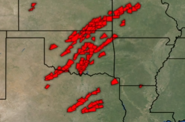
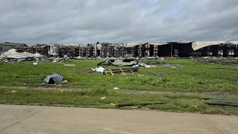
The saying is April showers bring May showers, this April the Southern Region saw their fair share of showers, some of these showers being particularly severe storms with heavy rainfall. Most of the severe weather across the region was seen in the ArkLaTex region to start the month, shifting westward into the Southern Plains by the end of the month, following climatological normals. Heavy rain and strong straight-line winds were associated with a line of storms as they moved from Texas into Louisiana from April 9th - 10th. Out of this storm system an EF-1 tornado was seen in Katy, TX, 70 mph winds struck Baton Rouge, LA, injuring 4 people, and an EF-2 tornado tracked through Slidell, LA damaging homes and businesses. As the month progressed, the weather pattern only became more active. On April 25th storms fired along the dryline in West Texas, and this kicked off what would be a historic 4-day severe weather outbreak. Storms from the night of the 25th grew upscale and tracked into Texas and Oklahoma as a line of storms on the morning of the 26th. One cell dropped an EF-0 tornado in the town of West, TX. As this system continued to track northeast into Arkansas it dropped several more EF-0 and EF-1 tornadoes. April 27th was the most destructive day of the bunch; in Texas and Oklahoma there were over 20 confirmed tornadoes, one being an EF-3 (read more about it here) and one an EF-4. The EF-4 tornado that occurred in Marietta, OK, caused extensive damage to a Dollar Tree distribution center and unfortunately ended one person's life. Storms grew upscale again and tracked slowly across Texas overnight on the 27th into the morning of the 28th. Once storms reached the Brazos Valley they became severe, leading to a couple of EF-0 and EF-1 tornadoes. Storms continued to fire over the region throughout the night of the 28th leading to extensive flooding. This led to Texas Governor Greg Abbot to issue a severe weather disaster declaration for East Texas. To finish out the month one final severe threat occurred on April 30th when a strong tornado dropped northeast of Hollister. Thankfully, the tornado impacted empty fields and farmlands, leading to its EF-1 rating.
Despite ongoing severe and damaging weather during April, Texas crops continued to progress. According to the USDA, corn crops are doing very well, improving as the month progressed. However, Oklahoma did not receive as much rain as areas of Texas, Louisiana, and southern Arkansas which led to expanding and worsening drought conditions in northern Oklahoma. Despite this, pasture and range conditions were rated 73% good to fair.
Temperature:
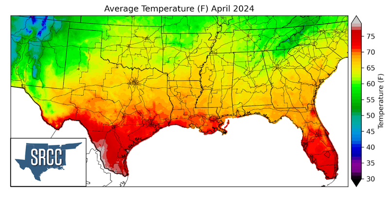
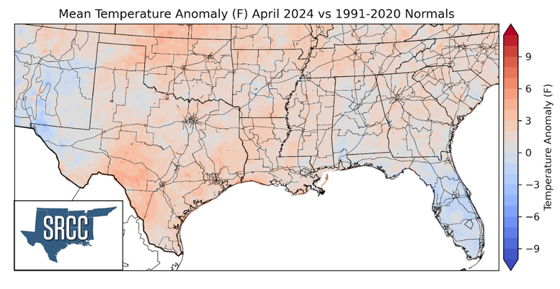
Temperatures were above normal across the Southern Region for the month of April. The largest departure from normal was observed in northern Oklahoma and southwest Texas, averaging about 5 degrees Fahrenheit above normal. The Southern Region started out the month with mild temperatures as several cold fronts kept temperatures from getting too unseasonably warm. This remained the case until the week of April 14th. Mid-month temperatures were warm all around the region, and weekly average temperatures were reaching 85 degrees Fahrenheit in the Lower Rio Grande Valley. Despite some more cold fronts, many of them weak, temperatures remained warm to finish out the month. The final week was the warmest, as much of Texas experienced weekly average temperatures of 75 degrees. This all resulted in April’s average temperatures for the Southern Region ranging between 73 and 60 degrees in most places. Some of the warmest daily average temperatures for March were found in the Lower Rio Grande Valley, where monthly average temperatures were as high as 80 degrees Fahrenheit.
Precipitation:
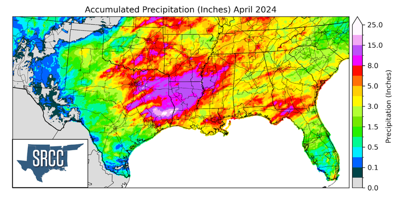
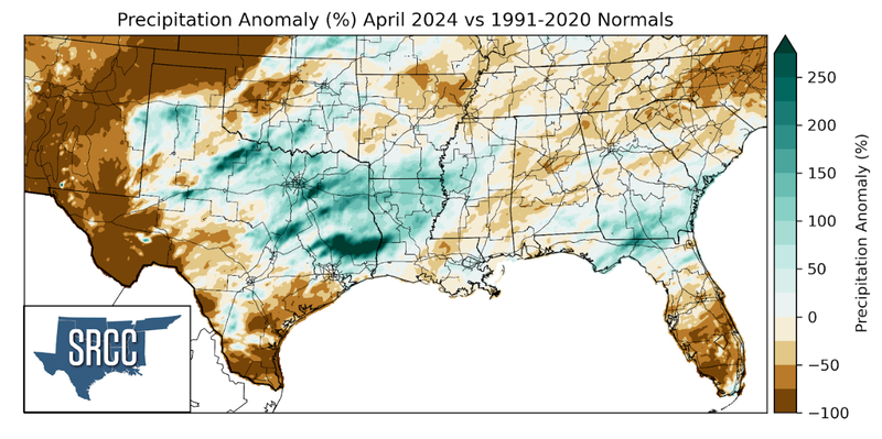
Near-normal precipitation totals were seen in about half of the Southern Region. Meanwhile, the other half, including East Texas, Louisiana, Southern Oklahoma, and Southern Arkansas, all saw above-normal rainfall totals. Specifically, precipitation totals were more than 3 times greater than normal in parts of Southeast Texas.
This April, many severe and non-severe storms popped up along the dryline in West Texas. When conditions were favorable, individual storms would organize into a line of storms and would track eastward across the Region. Another focal point for rainfall this month was a set of advancing cold fronts that eventually stalled near the Gulf Coast, becoming a stationary boundary. Between all these initiations of storms this past month, slow-moving storms led to flash flooding on many occasions. One of the first of many events occurred on April 10th, when much of Louisiana was under a flash flood warning. Before storms moved into Louisiana, 12 inches of rain fell in Tyler County in East Texas according to a CoCoRaHS report. Precipitation totals set records from this event, with 2.10 inches of rain falling in just one hour in Slidell, LA, setting the record for April. This event resulted in much of northern Louisiana receiving at least 8 inches of rain. On April 20th a stationary front draped itself along the Gulf Coast, bringing steady and sometimes heavy rainfall throughout the Gulf states. Heavy rainfall from this event led to overflowing creeks and flooded roadways in the Brazos Valley of Texas. Flooding only became more severe as a slow-moving storm system moved into the Brazos Valley the night of April 28th. This resulted in many flooded/closed roads. Wolf Pen Creek in College Station, TX rose significantly and became over 200 ft wide after over 6 hours of nonstop rain. The majority of the Eastern Brazos Valley received 8 inches of rain that night with some areas seeing upwards of 11 inches. Monthly rainfall totals were also quite substantial in this area totaling upwards of 20 inches. Tyler and Polk County in Southeast Texas also saw extensive and even more severe flooding from these events. Rainfall totals for the month reached 25 inches in the two counties!
Overall, precipitation this month followed an anticipated pattern, with the highest accumulations concentrated among East Texas, north-central Louisiana, and southern Arkansas as that is where the highest probability of severe weather and rainfall is in April. The majority of this area saw above-normal rainfall totals, with the majority of the area seeing a minimum of 12 inches for April.
Drought:
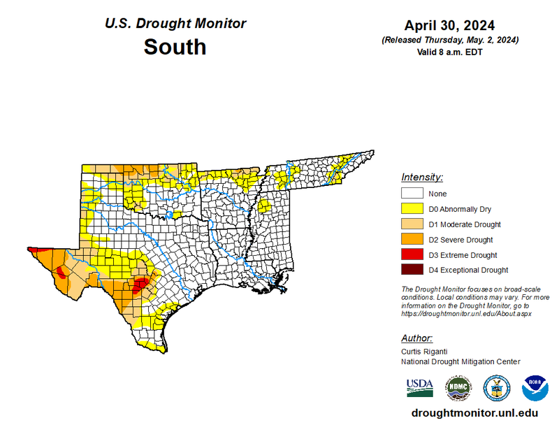
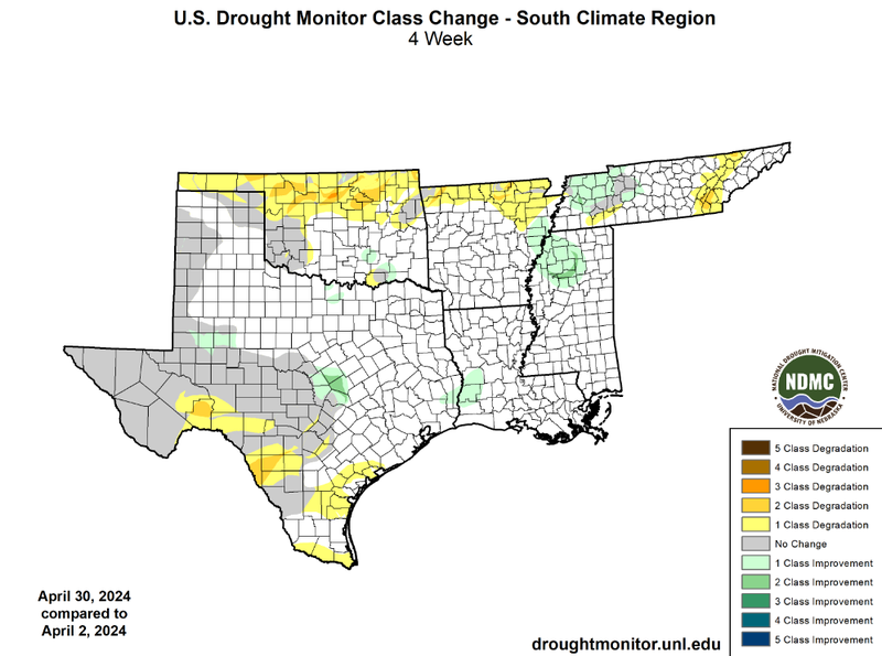
In April, plentiful moisture and other ingredients for storms were common in East Texas, north-central Louisiana, and southern Arkansas and the Southern Plains, resulting in semi-frequent rainfall, sometimes heavy rainfall. Temperatures started the month mild and then favored warmer-than-normal averages as the month drew to a close. Despite these favorable conditions, areas of Northern Oklahoma, Northern Arkansas, and Southwest Texas failed to see considerable rainfall throughout April. This led to the expansion of drought conditions in the three areas with the addition of areas of the Rio Grande Valley and the Smoky Mountains of Tennessee. The most vast expansion and worsened drought conditions were observed in northern Oklahoma, where widespread one-class degradation was seen as well as significant two-class degradations. There was a similar story for areas of Southwest Texas that saw storms forming to its east for the majority of the month. While improvements were far less widespread than our winter months, Central Texas, western Louisiana, northern Mississippi, and western Tennessee did manage to see some one-class improvements as well as isolated two-class improvements. Additionally, some small one-class improvements were seen in West Texas and southern Oklahoma. Unfortunately, though, a lack of significant rainfall continued for Northwest Oklahoma this month, which ended March in flash drought conditions. Some areas received less than an inch of rain all month in the Northwest corner of the state, helping lead to the 5th driest March-April for the state. Overall, at a regional level, drought conditions expanded slightly. At the beginning of April, 14% of the region was experiencing D1-D4 drought conditions, versus 18% by the end of April. Drought severity also expanded slightly with 5% of the region experiencing D2-D4 coverage to start the month and 8% by the end.
According to the U.S. Monthly Drought Outlook for this May, drought is expected to remain yet improve in Southwest Texas. Drought is expected to persist in Far West Texas and areas of the Rio Grande Valley. Drought development is likely in areas of the Texas and Oklahoma Panhandles. Finally, drought removal is likely in northern Oklahoma, northern Arkansas, and isolated areas of Southwest Texas.
