11/16/2025 - 11/22/2025
Climate in the News:
A majority of the Southern Region saw measurable rainfall this past week, and that trend is expected to continue into Thanksgiving week. The bulk of rainfall from Sunday (11/23/25) through Saturday (11/29/25) will fall across the eastern parts of the Region, where totals of an additional 1” to 1.5” inches are expected with localized higher amounts. This is mainly due to a low-pressure system tracking eastward through the central plains on Monday (11/24/25), which will bring a threat of severe weather and rain potential to the southern parts of the region. The second round will come from a strong low-pressure system moving eastward across the northern United States, with a trailing cold front expected to impact the region by Friday. Temperatures in the eastern parts of the Region, including Tennessee, Arkansas, and Mississippi, will drop into the low 40s and mid-30s by the end of the week. Overall, the entire Region will return to more seasonable average temperatures by the end of Thanksgiving week.
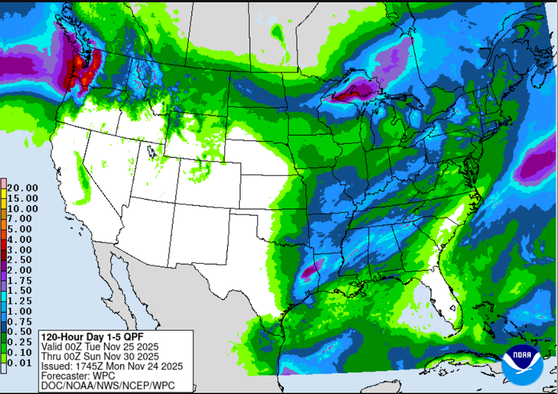
Weather Prediction Center Cumulative Rainfall total forecast 11/25/25-11/30/25
Weather Synopsis:
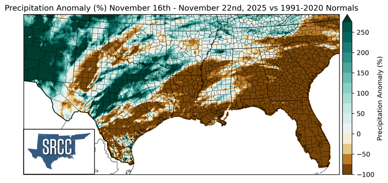
A frontal system passed through the Southern Region from Thursday (11/20/25) through Friday (11/21/25) and produced a blanket of rainfall across the region, with many areas receiving close to an inch of rainfall. That was mainly due to the long length of the system, with the central low pressure center located over south eastern Canada and its trailing cold front losing momentum as it entered the Region. This allowed for continuous rainfall over western and central Texas and provided crucial precipitation to some of the most drought-stricken areas of the Southern Region.
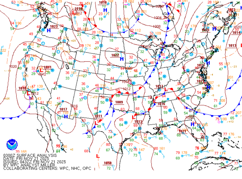
Weather Prediction Center Surface Map Analysis: November 21st, 2025 valid 9pm CST.
Temperatures:
Due to the length of the system stretching from the very southern portions of the United States to Southern Canada, the frontal passage brought relief in the form of rainfall but not in the form of temperatures. Overall, the system lacked enough strength to bring temperatures below seasonal averages, and southerly flow from the Gulf quickly returned, which advected warm and humid air across the Region.
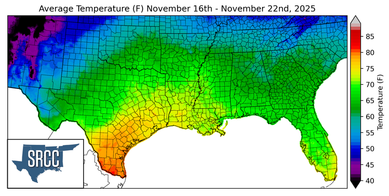
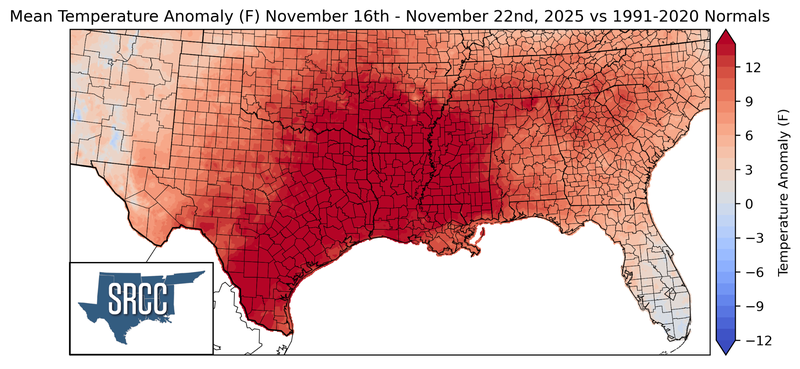
As a result, the entire Region experienced temperatures at least three degrees Fahrenheit above normal. Central parts of the region which included eastern Texas, Louisiana, and western Mississippi experienced temperatures 9 to 12 degrees Fahrenheit above normal, with some mesonet stations setting record highs. Due to the abnormally high temperatures, most of the Region saw temperatures in the mid 70s with portions of South Texas and central Louisiana having averages around the mid to low 80s.
Precipitation:
With the frontal boundary stalled over western and central Texas, the majority of the week's rainfall occurred in said areas. In the Dallas-Fort Worth Metroplex, CoCoRaHS recorded more than 4 inches of rainfall over the two day period from Thursday (11/20/25) through Friday (11/21/25) such as in Plano, McKinney, and Arlington. The highest total in the Southern Region came from Menard, Texas located in the western portion of the state, which CoCoRaHS observed measured 8.9” of rainfall over the two day period. This aligns with radar-estimated rainfall, which showed widespread totals in the area reaching 5” of rain fall with localized higher amounts.
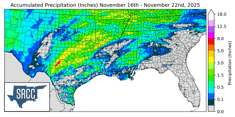
Portions of Louisiana and South Texas, where temperatures were significantly above normal also remained abnormally dry, with minimal precipitation recorded throughout the week.
Drought:
An updated Drought map has not been released to account for the late-week rainfall that brought much needed precipitation to some of the region’s most drought-stricken areas.
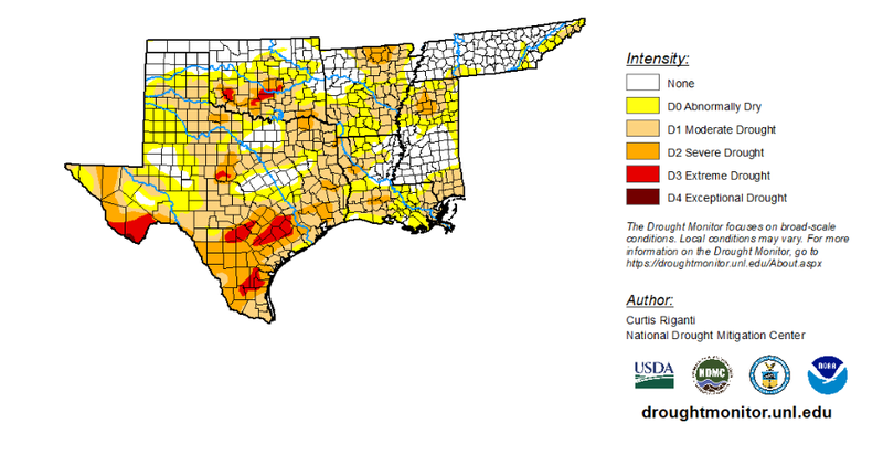
Before this week’s rainfall Abnormally Dry (D0) to Exceptional Drought (D4) conditions expanded to cover 74.35% of the Southern Region, up from 71% from the previous week. Overall, drought conditions expanded in nearly every category except for Exceptional Drought (D4), which continued to only cover 0.07% of the region in the western Texas Panhandle. However, once the new map incorporates the widespread late-week precipitation, many of these drought percentages will likely decrease across the Region.